Links:
POST Rancho San Vicente Hike, April 10, 2010
POST Rancho San Vicente Hike, June 13, 2009
Peninsula Open Space Trust
POST on Facebook
POST: Rancho San Vicente
Flickr: Rancho San Vicente Pictures
Mercury News Article on Rancho San Vicente,
San Jose Business Journal article on Rancho San Vicente
Santa Clara County Parks
Almaden Quicksilver County Park
Calero County Park
Santa Teresa County Park
SCC Open Space Authority
Rancho Canada Del Oro Open Space Preserve
Canada Del Oro and Calero Trail Map
Mid-Peninsula Regional Open Space District
Sierra Azul Open Space Preserve
Bay Area Ridge Trail
Ridge Trail Guidebook
Park and Trail Pages:
Blair Ranch Hike 3/28/10
Blair Ranch Hike, 5/9/09
Doan Ranch Page 1, Page 2
Los Alamitos Creek Trail
Guadalupe River Park and Gardens:
Guadalupe River Trail
Guadalupe Creek Trail
Coyote Creek Trail
Bay Area Biking
Bay Trails, South Bay
Bay Area Parks
Friends of Santa Teresa Park
Almaden Quicksilver Park
Bay Area Back Pages
SF Bay Rec & Travel
Rancho Canada Del Oro Hike, 5/16/09
Rancho Canada Del Oro Hike, Mayfair Ranch Trail, 3/14/10
Calero Healthy Trails Hike, 4/25/09
Uvas Canyon Healthy Trails Hike, 2/21/09
Coyote Ridge Wildflowers, 4/13/08
Almaden Quicksilver Wildflowers and Views, Spring 2008, Part 2
Healthy Trails Walk, Almaden Quicksilver 3/28/09
Harvey Bear Ranch-Coyote Lake Pictures, 3/10/07, 3/21-21/09, 4/18/09
Palassou Ridge 6/6/09
Mt. Madonna Geocaching Class, 7/11/09
Hellyer HDR Pictures 1/10/10
Almaden Quicksilver Wood Road Geocaching Class 1/16/10
Uvas Canyon HDR Pictures 1/23/10
Joseph D. Grant County Park, 1/31/10
Uvas Canyon Hike, 2/13/10
Santa Teresa Park Pictures:
Santa Teresa Park Mine, Fortini, Stile Ranch Wildflowers, 4/11/08
Coyote Peak, Rocky Ridge Wildflowers, Feb-Apr. '08
Bernal Hill wildflowers and views, Feb-Apr. '08 Part 1, Part 2
Coyote Peak, Rocky Ridge, Feb-April '08
Mother's Day Walk, Fortini-Stile, 5/4/08
Outdoor Photography Class/Wildflower Walk, Bernal Ranch/Hill 4/4/09
Geocaching Class, Fortini-Mine-Stile Ranch Trail, 4/11/09
Pre-Mother's Day Walk, Fortini-Mine-Stile Ranch Trail, 5/3/09
Healthy Trails Hike, Fortini, Mine, Stile Ranch Trails, 5/9/09
Santa Teresa Sunset Pictures 2/7/10
Ron Horii's Outdoor Photography Pages:
Outdoor Photography
Outdoor Photo Gallery
HDR Experiments,
Part 2
Rancho San Vicente Outdoor Photography/Wildflower Hike, April 17, 2010
Rancho
San Vicente is an active cattle ranch located north of Calero County
Park, south of Almaden Quicksilver County Park, and west of Santa
Teresa County Park. There were plans to build a golf course and homes
on the property. On
June 1, 2009, the Peninsula
Open Space Trust (POST) purchased
the 966-acre rancho, protecting it from development. The
Santa Clara County Board
of Supervisors authorized
the County Parks dept. to proceed with the purchase of Rancho San
Vicente from POST on 8/11/09. The
ranch
was purchased by the Santa Clara County Parks for $16 million in 2009. The money
came from the County Park's Charter Fund. It is now County Park
property, but
it is not yet open to the public on a daily basis. There will be guided
tours of the park by the County Parks Dept. and by POST. On 4/17/10 was
the first of the guided hikes by the County Parks. It was a photography
class and wildflower walk, led by docents Ron Horii and Cait Hutnik,
with help from Friends of Santa Teresa Park president Mike Boulland and
SCCOSA docent Tom Cochrane. Ron, who has been teaching outdoor
photography
classes and hikes for the county parks, talked about photography. Cait
Hutnik, who leads Healthy Trails hikes, talked about wildflowers. Here
are some pictures from that hike.

We met at the Calero Reservoir. Across from Calero, we could see our destination: the peak of Rancho San Vicente (right of center).

We assembled at the Calero Reservoir parking lot, which has restrooms. We then caravaned over to Rancho San Vicente on McKean Road, led by ranger Fernando Elias.

We parked at the corral and walk up the trail. Cait Hutnik (right) gave a talk on trail safety.

Walking up the ranch road. The Stile Ranch Trail in Santa Teresa Park goes up the hill in the background on the right.

Farm pond

Above the Almaden-Calero Canal

At a small pond fed by a spring at the base of the hill.

Douglas' microseris, also called Douglas' silverpuffs

Bee plants


Hillside covered with poppies, silverpuffs, popcornflowers, and birdseye gilia

Pink owl's clover among the popcornflowers and poppies

Passing by a patch of seep-spring monkeyflowers

Overlooking a patch of creamcups, poppies, and popcornflowers, with a view of the north part of Rancho San Vicente and the Almaden Valley

The part of the trail has a gentle slope.

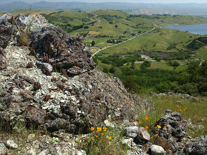
Lichen-covered rocks, with the Almaden Valley in the background.

Closeup of California gilia


Goldfields in the foreground, Almaden Road in the background.

Mike Boulland points out New Almaden and Almaden Quicksilver.

View of the Casa Grande in New Almaden, with the hills of Almaden Quicksilver in the middle ground. The New Almaden Chimney can be see on the hill on the left. The Sierra Azuls topped by Mt. Umunhum are in the background.

Patches of goldfields and dwarf plantain on the hillside.

Poppies and plantain by a lichen-covered rock.


The trail turns and begins to ascend more steeply.

Golden yarrow and bluedicks in the foreground, hills of Rancho San Vicente in the mid-ground, Santa Teresa Hills in the background.

Photographing the yarrow.

Tom Cochrane looking at a jeweled onion.

The trail turns. In the background are the hills of Almaden Quicksilver County Park above New Almaden.

Continuing around the bend. In the background is the South Almaden Valley.

Goldfields cover the slopes near the peak. The grass has been cut short by cattle grazing. The trail reaches a junction. A service road goes up to the peak of the hill.


Tom Cochrane looking at the serpentine morning glory (2 are in the foreground), surrounded by goldfields and birdseye gilia.

Near the antenna-topped peak of the hill.

Looking back from near the top of the peak towards the South Bay Area.

Looking towards the Santa Teresa Hills from the peak.

Making the final ascent to the peak.

Rocks at the peak with dudleya, surrounded by a variety of wildflowers.

At the peak, near the antenna. This is the highpoint of Rancho San Vicente, at about 1050 feet.

Endangered Santa Clara dudleya on rocks on the peak. We step carefully to avoid them, following the path previously laid out by POST.

Pink bitterroot flower growing in the rocks.

View from the peak of Calero Reservoir and the hills immediately west of it.

View from the peak of the Santa Teresa Hills southwest of Santa Teresa Park, which is the next set of hills behind them.
Dudleya-covered rocks, McKean Road, and Calero Reservoir.

Calero Dam and Calero Reservoir. The border of Rancho San Vicente is very close to the shore of Calero (see map below).

Mike Boulland pointing out the points of interest.

The service road in the center follows along the hills in Rancho San Vicente.

In the background are the Bald Peaks of Calero County Park and Rancho Canada Del Oro Open Space Preserve.

Dudleya in the foreground, New Almaden in the background, looking back at the trail we came up.

Coming down from the peak. The slopes are covered with goldfields.

Golden yarrow in the foreground.

The sun has opened up the poppies lining the trail.


Dudleya cover the rocks.


Creamcups and poppies above the Almaden-Calero Canal.

At the ranch gate.

A gopher snake crosses the road.
County Parks Staff and Docents Hike 2/28/10

Carrie and Bill head up the trail where cattle are grazing along the route. The antenna-topped peak is ahead, but we follow the road around its flanks on the right.

Bill and Carrie take the trail along the side of the hill.

Cait takes pictures of the flowers.

Santa Clara Valley dudleya and poppies grow on the rocks and serpentine soil on hill above the road.

Carrie, Jan, and Cait look at some interesting insects.

Carrie, Sam, and Jan hike up another hill where cattle are grazing.

View of Calero Reservoir

View of the nearby hills. The tall ridge in the background is in Calero and Rancho Canada Del Oro.

Cait and Jan on the hill, with the Sierra Azuls in the background.

Cait, Carrie, Sam, Jan, and Ron posing on the hill trail. In the background is the peak with the antenna. Note how the peak is a different color because of the serpentine soil. The near hills have clay soil and different flowers.

Jan, Cait, Sam, Carrie, and Ron on the hill, with Calero Reservoir in the background. We're at about 918 feet. We head back from here.

Yellow johnny jump-ups and pink checkerblooms are starting to pop up on the hills. The cattle have cropped the grasses, allowing the wildflowers to grow.

This road leads down the valley to the edge of the property, near Cinnabar Hills Road.

We head back through a stand of manzanitas.
Map of Rancho San Vicente

County Parks Rancho San Vicente Hikes, 2010
We met at the Calero Reservoir. Across from Calero, we could see our destination: the peak of Rancho San Vicente (right of center).
We assembled at the Calero Reservoir parking lot, which has restrooms. We then caravaned over to Rancho San Vicente on McKean Road, led by ranger Fernando Elias.
We parked at the corral and walk up the trail. Cait Hutnik (right) gave a talk on trail safety.
Walking up the ranch road. The Stile Ranch Trail in Santa Teresa Park goes up the hill in the background on the right.
Farm pond
Above the Almaden-Calero Canal
At a small pond fed by a spring at the base of the hill.
Douglas' microseris, also called Douglas' silverpuffs
Bee plants
The endangered Santa Clara Valley
dudleya, which grows only in the
south Santa Clara Valley. The dudleya is one of several rare or
endangered plants and animals which live in Rancho San Vicente, which
was one of the key reasons for the county purchasing the property. The
county's Habitat
Conservation Plan addresses the preservation of endangered species
in the county. Rancho San Vicente will be an important part of that
plan.
Hillside covered with poppies, silverpuffs, popcornflowers, and birdseye gilia
Pink owl's clover among the popcornflowers and poppies
Passing by a patch of seep-spring monkeyflowers
Overlooking a patch of creamcups, poppies, and popcornflowers, with a view of the north part of Rancho San Vicente and the Almaden Valley
The part of the trail has a gentle slope.
Lichen-covered rocks, with the Almaden Valley in the background.
Closeup of California gilia
Goldfields in the foreground, Almaden Road in the background.
Mike Boulland points out New Almaden and Almaden Quicksilver.
View of the Casa Grande in New Almaden, with the hills of Almaden Quicksilver in the middle ground. The New Almaden Chimney can be see on the hill on the left. The Sierra Azuls topped by Mt. Umunhum are in the background.
Patches of goldfields and dwarf plantain on the hillside.
Poppies and plantain by a lichen-covered rock.
Poppies, popcornflowers in the
foreground, goldfields in the middle,
houses on Cinnabar Hills Road in the background. The hill in the
background is private property. The property line for Ranch San Vicente
runs partway up the hill on the other side of the valley.
The trail turns and begins to ascend more steeply.
Golden yarrow and bluedicks in the foreground, hills of Rancho San Vicente in the mid-ground, Santa Teresa Hills in the background.
Photographing the yarrow.
Tom Cochrane looking at a jeweled onion.
The trail turns. In the background are the hills of Almaden Quicksilver County Park above New Almaden.
Continuing around the bend. In the background is the South Almaden Valley.
Goldfields cover the slopes near the peak. The grass has been cut short by cattle grazing. The trail reaches a junction. A service road goes up to the peak of the hill.
Tom Cochrane looking at the serpentine morning glory (2 are in the foreground), surrounded by goldfields and birdseye gilia.
Near the antenna-topped peak of the hill.
Looking back from near the top of the peak towards the South Bay Area.
Looking towards the Santa Teresa Hills from the peak.
Making the final ascent to the peak.
Rocks at the peak with dudleya, surrounded by a variety of wildflowers.
At the peak, near the antenna. This is the highpoint of Rancho San Vicente, at about 1050 feet.
Endangered Santa Clara dudleya on rocks on the peak. We step carefully to avoid them, following the path previously laid out by POST.
Pink bitterroot flower growing in the rocks.
View from the peak of Calero Reservoir and the hills immediately west of it.
View from the peak of the Santa Teresa Hills southwest of Santa Teresa Park, which is the next set of hills behind them.
Dudleya-covered rocks, McKean Road, and Calero Reservoir.
Calero Dam and Calero Reservoir. The border of Rancho San Vicente is very close to the shore of Calero (see map below).
Mike Boulland pointing out the points of interest.
The service road in the center follows along the hills in Rancho San Vicente.
In the background are the Bald Peaks of Calero County Park and Rancho Canada Del Oro Open Space Preserve.
Dudleya in the foreground, New Almaden in the background, looking back at the trail we came up.
Coming down from the peak. The slopes are covered with goldfields.
Golden yarrow in the foreground.
The sun has opened up the poppies lining the trail.
Dudleya cover the rocks.
Creamcups and poppies above the Almaden-Calero Canal.
At the ranch gate.
A gopher snake crosses the road.
County Parks Staff and Docents Hike 2/28/10
On 2/28/10, docents Ron Horii,
Cait Hutnik, and Sam Drake accompanied park staffers Carrie Grisenti,
Jan Shriner, and ranger Bill Burr on a scouting hike of Rancho San
Vicente. It was early in the season, and the wildflowers were just
starting to come out. The carpets of wildflowers that we saw in April
had not come out yet. Here are pictures from that hike, of the areas
not included in the above hike.
Carrie and Bill head up the trail where cattle are grazing along the route. The antenna-topped peak is ahead, but we follow the road around its flanks on the right.
Bill and Carrie take the trail along the side of the hill.
Cait takes pictures of the flowers.
Santa Clara Valley dudleya and poppies grow on the rocks and serpentine soil on hill above the road.
Carrie, Jan, and Cait look at some interesting insects.
Carrie, Sam, and Jan hike up another hill where cattle are grazing.
View of Calero Reservoir
View of the nearby hills. The tall ridge in the background is in Calero and Rancho Canada Del Oro.
Cait and Jan on the hill, with the Sierra Azuls in the background.
Cait, Carrie, Sam, Jan, and Ron posing on the hill trail. In the background is the peak with the antenna. Note how the peak is a different color because of the serpentine soil. The near hills have clay soil and different flowers.
Jan, Cait, Sam, Carrie, and Ron on the hill, with Calero Reservoir in the background. We're at about 918 feet. We head back from here.
Yellow johnny jump-ups and pink checkerblooms are starting to pop up on the hills. The cattle have cropped the grasses, allowing the wildflowers to grow.
This road leads down the valley to the edge of the property, near Cinnabar Hills Road.
We head back through a stand of manzanitas.
Map of Rancho San Vicente

This
is a picture of POST's satellite map showing the boundaries of Rancho
San Vicente. Click on the image for a full-sized version. You can see
how a large part of the east side of the ranch abuts Calero County
Park. The west side abuts New Almaden on Almaden Road and comes very
close to Almaden Quicksilver County Park.

This shows a closeup of the
climb to the peak. The POST hike went up to
the top of the peak. The docent's hike went along the side of the peak
and along the top of the ridge to the right.
Google Earth Maps and Track


This is a view from Calero Dam in Calero County Park, looking southwest towards Rancho San Vicente, whose peak is on the upper right. The property line for the ranch is just above the Cherry Cove Trail in Calero.


Topo 8 Maps

Above is a DeLorme Topo
8 map, with the hiking route show in red, downloaded from a PN-30 GPS
receiver. It actually shows 2 hikes, the POST hike on 4/10 (today's
hike followed the same route) and a County
Parks docent hike on 2/28/10, which started at Calero Reservoir in
the background and ended on the hillside ridge to the right.(Note:
the maps below were copied from the 4/10/10
POST hike webpage.) The
following tracks were obtained from a DeLorme PN-30 GPS unit,
downloaded into Topo 8, and imported into Google Earth to provide 3-D
satellite maps of the hike and associated lands. Click on each image
for a full-size version.

Looking
southwest, the hiking route is shown above in blue, starting at
the McKean road entrance at the lower right and the peak at the upper
left. The thick white line that crosses the route is the Almaden-Calero
Canal. In the background are New Almaden (right of center) and Almaden
Quicksilver County Park (upper right).

This
is the hiking route,
looking southeast, with the crossing of the Almaden-Calero Canal on the
lower left, and the peak in the center. The canal runs across the
bottom of the page to Calero Reservoir in the upper left. In the
background on the right is the Bald Peaks of Rancho Canada Del Oro.

This
is a view looking
northeast. The Rancho San Vicente peak is at the center right. Near the
upper left, the blue line goes down McKean Road to Fortini Road and the
Stile Ranch Trailhead of Santa Teresa Park, which is in the background.
The high point of Santa Teresa Park is Coyote Peak, which is near the
top center.

This is a view from Calero Dam in Calero County Park, looking southwest towards Rancho San Vicente, whose peak is on the upper right. The property line for the ranch is just above the Cherry Cove Trail in Calero.

This
is a view looking northwest from the Bald Peaks at the boundary of
Calero County Park (at the Chisnantuck Trail on the right) and Rancho
Canada Del Oro Open Space Preserve (at the Catamount Trail on the
left). Calero Reservoir is on the right. The peak of Rancho San
Vicente is just right of top center.

This
is a long view of Rancho San Vicente, looking south, with Calero
on the center left, the Bald Peaks a little higher, left of center, the
Blair Ranch near the upper center, New Almaden on the right edge,
Almaden Reservoir above it, and Mt Loma Prieta in the background on the
top right of center.

This
is a long view of Rancho
San Vicente, looking west from the peak, with New Almaden in the
center, the Almaden Valley on the right, Almaden Reservoir left of
center, Almaden Quicksilver County Park to the right of center, and the
ridge of the Sierra Azul Open Space Preserve in the background, with
Mt. Umunhum near the top center.
Topo 8 Maps


County Parks Rancho San Vicente Hikes, 2010
This
is a list of County Parks hikes in 2010 at Rancho San Vicente. See
the County
Parks Activities Calendar for the latest updates. Also see the Play
Here Brochure.
- Saturday April 17, Outdoor Photography & Wildflower Hike, Rancho San Vicente, 9:30am-12:00pm. Join Docents Ron Horii and Cait Hutnik to learn the basics of outdoor photography while weaving through a colorful display of wildflowers. Meet at the Calero Reservoir parking lot to caravan. Bring sun protection, water and sturdy hiking shoes. This hike is in a “closed area” not yet open for public access. No restroom available except at meeting location. Pre-registration required, limit 20 people. (408) 355-2240.
- Saturday, June 5, Raptors Over the Rancho, Rancho San Vicente, 4:00pm – 6:00pm. Take a hike with a Park Ranger in this future County Park. Learn to identify our local sky-hunting hawks, eagles and other raptors. Participate in an activity that demonstrates hunting practices of these magnificent birds. Meet at Calero Reservoir, then caravan to the site nearby. Bring sturdy hiking shoes, sun protection and water. Note: This hike is in a “closed area” not yet open for public access. Restrooms not available except at meeting location. (408) 268-3883.
- Friday, June 18, Exploring Local Wildlife Hike, Rancho San Vicente, 5:30pm-8:00pm. Learn about local wildlife and tracking skills on this strenuous 2-mile hike in a beautiful future County Park. Meet at the Calero Reservoir parking lot to caravan to the tour location nearby. Bring sturdy hiking shoes, water, flashlight and binoculars (optional). Reservations required prior to 6/17. Note: This hike is in a “closed area” not yet open for public access. Restrooms not available except at meeting location. Pre-registration required. (408) 323-1107.
- Saturday, July 17, Ranger-led Hike, Rancho San Vicente, 9:00am-11:00am. Take a strenuous 2-mile hike with at Park Ranger to explore this neighbor to Calero and future County Park. Learn about the history of the rancho property and explore plants and wildlife living here. Meet at Calero Reservoir to caravan to tour site nearby. Bring sturdy hiking shoes, sun protection and water. Note: This hike is in a “closed area” not yet open for public access. Restrooms not available except at meeting location. (408) 268-3883.
- Friday, August 27, Tragedy of the Berryessas Hike, Rancho San Vicente, 6:00pm-8:00pm. Take a hike into the past in this future County Park. Learn of the tragedies that befell the Berryessa family and their rancho. Explore historic connections to the New Almaden Mines and take in spectacular views of New Almaden and Ranchos San Vicente and Los Capintancillos. Meet at the Calero Reservoir parking lot to caravan to the nearby tour location. Bring sturdy hiking shoes, water, flashlight and binoculars (optional). Reservations required prior to 8/23. Note: This hike is in a “closed area” not yet open for public access. Restrooms not available except at meeting location. Pre-registration required, space limited. (408) 323-1107.
- Saturday, September 11, Ranger-led Hike, Rancho San Vicente, 8:30am-10:30am
- Saturday,
October 9, Ranger-led Hike, Rancho San Vicente, 9:00am-11:00am
Links on Rancho San Vicente
- Board of Supervisors Meeting Agenda 8/11/10
- Habitat Conservation Plan memo recommending the purchase of Rancho San Vicente
- Property map
- Morgan Hill Times: "Rancho San Vicente Protected"
- Sam Drake's pictures of the Rancho San Vicente Hike by County Park docents and staff, 2/28/10. Pictures and GPS Track.
- Tom Cochrane's pictures of the 4/17/10 hike
- Kate
Martin's Kodak slideshow of Rancho San Vicente
- Marty Reinder's pictures
of the 4/17/10 hike: hills with
flowers, bird's
eye gilia, creamcups,
panoramic
view (below, click on thumbnail for a full-size 7MB version)


Environmental
Links
- USFWS: Recovery Plan for Serpentine Soil Species of the San Francisco Bay Area.
- USFWS:
Designation of Critical Habitat for the Bay Checkerspot Butterfly
- Drive-by Extinction - Bay Checkerspot Butterfly
- Santa Clara Valley Habitat Conservation Plan
- Santa
Clara County Habitat Conservation Plan, Natural Communities
Conservation Plan Factsheet
- Santa
Clara County HCP/NCCP Conservation Planning Strategies Report
Created
by Ronald Horii, 4/22/10