Links
Park Links
Alviso Marina County Park
Santa Clara County Parks
Don Edwards SF Bay Nat'l Wildlife Refuge
San Francisco Bay Trail
Ron Horii's Bay Trail Pages
Alviso Town and Slough
Alviso Mallard Slough, Envir. Ed. Center
Guadalupe River Trail: 101 to Alviso
Guadalupe River Park & Gardens
San Tomas Aquino Creek Trail
Sunnyvale Baylands 2011
Moffett Bay Trail
Stevens Creek Trail
Shoreline at Mountain View
Palo Alto Baylands 2009
Palo Alto Baylands 11/26/11
Ravenswood Bay Trail
Port of Redwood City Bay Trail
Friends of Santa Teresa Park
High-Dynamic Range Photography
HDR Experiments -1
HDR Experiments -2
HDR Hellyer Sunset
HDR Uvas Canyon Waterfalls
Grant Ranch, 1/31/10
Santa Teresa Park HDR Sunset Pictures, Pueblo Area, 2/7/10
Almaden Quicksilver, 2/27/10
Santa Teresa Park HDR Sunset Pictures, Norred Trail 5/21/10
Stile Ranch Trail 1/29/11
Santa Teresa Park Rainbows 1/30/11
Outdoor Photography
Ron Horii's Outdoor Photography Pages
Outdoor Photo Gallery
Photo Class, Wildflower Walk, Santa Teresa Park, 4/4/09
Rancho San Vicente Photo Class Hike 4/17/10
Outdoor Photography Class, Bernal Ranch, 10/2/10
Class at Coyote Lake 4/23/11
Park Photography Show, Santa Teresa Library Sept. 2011
Alviso Marina County Park Sunset Pictures, November 27, 2010
Alviso Marina is located at the
end of the Guadalupe River and the
start of the Alviso Slough, in the historic community of Alviso. Alviso
was once a small, independent town, incorporated in 1852, but became
part of San Jose in 1968. It provides San Jose's only boat access to
San Francisco Bay. It was once a bustling seaport in the mid-19th
century, shipping agricultural products from the Santa Clara Valley and
mercury from the New Almaden Mines. Competition from railroads resulted
in the decline of shipping. In later years, ground subsidence from
over-drawing underground water caused the town to sink below sea level,
resulting in the need for levees to protect it from floods.
Adjacent marshes were diked to create salt ponds. In 1964, Santa Clara
County purchased land from the salt company and built a marina. The
marina had a 9-acre basin and 76 boat slips. High levels of sediment
required costly dredging to keep the marina open. In the 1980's,
dredging ceased, and the marina was allowed to fill in with sediment
and bulrushes. While they could no longer be used for boating, the
launching slips remained as ghostly reminders of the former marina that
became a marsh. In 2005, the County converted the ramps into boardwalks
for viewing wildlife and plants in the marsh. Viewing
platforms, access ramps, picnic tables, interpretive signs, and
landscaping were
added. One boardwalk allowed crossing the marsh to the Alviso Slough
Trail. On June 5, 2010, new boat launch ramps were opened. They are on
the Alviso Slough and provide access for kayaks, canoes, and small
powerboats.
Alviso Marina County Park is small, covering only 18.9 acres, but it is the gateway to the huge Don Edwards San Francisco Bay National Wildlife Refuge, which covers 30,000 acres around the South Bay. There are over 15 miles of trails in the Alviso section of the refuge, running on levees around former salt ponds.
These HDR (High Dynamic Range) pictures were taken at Alviso Marina County Park on November 27, 2010 in the late afternoon, as rain clouds were breaking up.

A stairway leads down to
one
of the former boat slips, now a viewing
platform on the marsh.

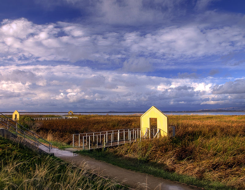
Entrance to the viewing platform.

This boardwalk leads across the marsh to the Alviso Slough Trail.

East of the marina are salt ponds and an active railroad line.

View looking across the marsh that fills the former marina.

View looking towards the parking lot for the marina.


Looking southeast towards Alviso. Below is a small pond. Behind it are the Southern Pacific Railroad Tracks. Behind them are the wetlands of the New Chicago Marsh.

Looking across a small pond at the historic buildings of Alviso.

Looking back towards the restroom and ramps and the marina.

The ramps and walkway at the marina.

The start of the boardwalk across the marsh.

Interpretive sign mid-way along the boardwalk across the marsh.

Interpretive sign at the former salt pond.

Looking back towards the new boat launching ramps.

The Alviso Slough Loop Trail.

Former salt pond next to the trail.

Terraces at the end of the parking lot form an amphitheater overlooking the marsh. The boat ramps are on the left.
Alviso Marina Opening, June 5, 2010

Ribbon-cutting at the boat docks

Boating rules and maps near the boat docks.

Launching kayaks

County Supervisor Dave Cortese (in blue) in the dragonboat, with Acting County Parks Director Julie Mark behind him

The dragonboat launches.

Crowds at the boat docks
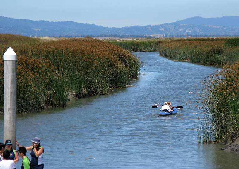
Kayak on the Alviso Slough. From the boat launching ramp, it is about 4 miles to San Francisco Bay.
Photographs by Ron Horii. Cameras: Olympus E-510 (11/27/10) and Canon A720IS (6 /5/10). HDR software: Photomatix Pro 3.2. Photo editing: Photoshop Elements 9. Page created by Ron Horii, 11/30/10, updated 12/12/11
Entrance to the viewing platform.
This boardwalk leads across the marsh to the Alviso Slough Trail.
East of the marina are salt ponds and an active railroad line.
View looking across the marsh that fills the former marina.
View looking towards the parking lot for the marina.
At the northeast corner of the
marina, the Alviso Slough Trail, part of the San Francisco Bay Trail,
begins on the former salt ponds that are now part of the US Fish &
Wildlife Service's refuge. The main trail loop runs for 9 miles along
the Alviso Slough, the Coyote River, and around the ponds. There is a
connection to the 5.5-mile Mallard Slough Trail loop to the east, which
leads to the Alviso Environmental Education Center. The trails are on
levees made of dried bay mud, and they get very soft and muddy in spots
after even a small amount of rain, so they are best taken in the
summer. The trails around the marina are paved, gravel, or decomposed
granite, so they are usable in the rainy season.
Looking southeast towards Alviso. Below is a small pond. Behind it are the Southern Pacific Railroad Tracks. Behind them are the wetlands of the New Chicago Marsh.
Looking across a small pond at the historic buildings of Alviso.
Looking back towards the restroom and ramps and the marina.
The ramps and walkway at the marina.
The start of the boardwalk across the marsh.
Interpretive sign mid-way along the boardwalk across the marsh.
Interpretive sign at the former salt pond.
Looking back towards the new boat launching ramps.
The Alviso Slough Loop Trail.
Former salt pond next to the trail.
Terraces at the end of the parking lot form an amphitheater overlooking the marsh. The boat ramps are on the left.
Alviso Marina Opening, June 5, 2010
On June 5, 2010, the Santa Clara
County Parks celebrated the opening of the boat docks at the Alviso
Marina. The project required dredging, brush clearing, construction of
a new parking lot, interpretive signs, launching ramp, and 2 floating
docks on the Alviso Slough. One of the docks is for kayaks and canoes.
The other is for motorboats. At the opening ceremony, there were
speeches by Acting County Parks Director Julie Mark, County Supervisor
Dave Cortese, San Jose mayor Chuck Reed, San Jose Councilmember Kansen
Chu, Water Board member Dick Santos, and other dignitaries. There were
informational, commercial, and community booths, entertainment, food,
and free kayak rides. There was a large dragonboat that also gave
rides. The marina provides San Jose's only public boat access to the
Bay. The project was funded through grants from the California
Department of Boating and Waterways and the San Francisco Bay Water
Trail Project, with land contributed in part by the California State
Lands Commission.
Ribbon-cutting at the boat docks
Boating rules and maps near the boat docks.
Launching kayaks
County Supervisor Dave Cortese (in blue) in the dragonboat, with Acting County Parks Director Julie Mark behind him
The dragonboat launches.
Crowds at the boat docks
Kayak on the Alviso Slough. From the boat launching ramp, it is about 4 miles to San Francisco Bay.
Photographs by Ron Horii. Cameras: Olympus E-510 (11/27/10) and Canon A720IS (6 /5/10). HDR software: Photomatix Pro 3.2. Photo editing: Photoshop Elements 9. Page created by Ron Horii, 11/30/10, updated 12/12/11