The Norred Ranch Site and Nearby Areas
The following are pictures from the areas around the former Buck Norred Ranch Site and other parts of the Santa Teresa Historical Area. Note: these pictures were taken over a period of years. These illustrate conditions in the area, but do not necessarily imply that these areas are all open to the public. Public access is technically not allowed on the Coyote-Alamitos Canal, the Bear Tree Lot, the Pyzak Ranch, the Pedro Bernal/Bonetti House, and the buildings around the Mounted Ranger Unit. Only marked trails and developed areas, such as Santa Teresa Spring and the Bernal-Gulnac-Joice Ranch, are open to public access.
Contents
- Maps
- Buck Norred Ranch Before the Mounted Ranger Unit
- The Coyote-Alamitos Canal by Santa Teresa Spring
- The Bear Tree Lot, Pyzak Ranch Area
- San Ignacio to Heaton Moor Drive
- Buck Norred Ranch Site/Mounted Ranger Unit
- The Mine Trail
- Coyote-Alamitos Canal to Bernal Road
- Fence Above the Coyote-Alamitos Canal
- Trail Routes Around the Mounted Ranger Unit
- The New Norred Trail
- Friends of Santa Teresa Park Links
- External Links
Click on the thumbnails below for a larger picture, then hit the "Back" button on your browser to return.
Maps
Note, these maps were derived from the current official park map, which is somewhat out of date and has some errors in the park boundary lines. This map
shows the Mine Trail, highlighted in purple, and the Coyote-Alamitos
Canal, highlighted in orange. Note that the Mine Trail begins at the
Norred
Ranch,, now the Mounted Ranger Unit. The only access to it is the
Coyote-Alamitos
Canal levee and the ranch road that leads out to Brockenhurst Drive.
Brockenhurst
Drive is now an official park entrance and can be used to access the
trailhead. The Coyote-Alamitos Canal
is
not a trail. The other official access to the lower Mine Trail is from
the
Hidden Springs Trail crossing, which is halfway up Bernal Road. The new Norred Trail will provide another way to
access it.
This map
shows the Mine Trail, highlighted in purple, and the Coyote-Alamitos
Canal, highlighted in orange. Note that the Mine Trail begins at the
Norred
Ranch,, now the Mounted Ranger Unit. The only access to it is the
Coyote-Alamitos
Canal levee and the ranch road that leads out to Brockenhurst Drive.
Brockenhurst
Drive is now an official park entrance and can be used to access the
trailhead. The Coyote-Alamitos Canal
is
not a trail. The other official access to the lower Mine Trail is from
the
Hidden Springs Trail crossing, which is halfway up Bernal Road. The new Norred Trail will provide another way to
access it.
 This is
a
detail showing the Buck Norred Ranchsite, now the home of the
Mounted Ranger Unit. The Coyote-Alamitos Canal is shown in orrange, but
the private section to the west of the Norred Ranch is shown in red.
The
blue line shows that private property extends above the canal and over
part of the old road leading up the hill. The green line shows a
hypothetical
trail route that would start at Heaton Moor in or near the Bonetti
Ranch
site, cross over the Coyote-Alamitos Canal, follow along the hillside
around
the back of the Mounted Ranger Unit, and intersect the Mine Trail
higher
up the hill. The Coyote-Alamitos Canal levee could be used to reach
this
trail junction from Santa Teresa Spring to the west. A connector trail
could be built along an existing volunteer trail to reach the
Coyote-Alamitos
Canal levee to the east, which runs to lower Bernal Road near the park
entrance. This would avoid the part of the canal that runs close to
houses
on Heaton Moor. Note that this route is only a conceptual
recommendation.
The actual route will be determined by the County Parks Department.
(Note: the trail has been built. See the new Norred Trail.)
This is
a
detail showing the Buck Norred Ranchsite, now the home of the
Mounted Ranger Unit. The Coyote-Alamitos Canal is shown in orrange, but
the private section to the west of the Norred Ranch is shown in red.
The
blue line shows that private property extends above the canal and over
part of the old road leading up the hill. The green line shows a
hypothetical
trail route that would start at Heaton Moor in or near the Bonetti
Ranch
site, cross over the Coyote-Alamitos Canal, follow along the hillside
around
the back of the Mounted Ranger Unit, and intersect the Mine Trail
higher
up the hill. The Coyote-Alamitos Canal levee could be used to reach
this
trail junction from Santa Teresa Spring to the west. A connector trail
could be built along an existing volunteer trail to reach the
Coyote-Alamitos
Canal levee to the east, which runs to lower Bernal Road near the park
entrance. This would avoid the part of the canal that runs close to
houses
on Heaton Moor. Note that this route is only a conceptual
recommendation.
The actual route will be determined by the County Parks Department.
(Note: the trail has been built. See the new Norred Trail.)
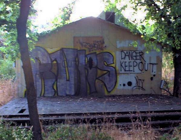
Buck Norred Ranch Before the Mounted Ranger Unit
These are pictures of the buildings at the Buck Norred Ranch before the area was turned into the Mounted Ranger Unit. Vandalism, graffiti and illegal entry of the buildings were common. Since the Mounted Rangers have moved in, this kind of activity has stopped. This
is
the rear of the ranch house at the Buck Norred Ranch site (7/10/01).
The house was covered with graffiti. The plywood that covered the
windows
was torn down in places. The inside of the house was heavily
vandalized.
This
is
the rear of the ranch house at the Buck Norred Ranch site (7/10/01).
The house was covered with graffiti. The plywood that covered the
windows
was torn down in places. The inside of the house was heavily
vandalized.
 This
small "honeymoon cottage" is next to the ranch house. It was also
covered with graffiti (7/10/01).
This
small "honeymoon cottage" is next to the ranch house. It was also
covered with graffiti (7/10/01).
 This
is the back of another small building by the ranch house. It was also
tagged. (7/10/01)
This
is the back of another small building by the ranch house. It was also
tagged. (7/10/01)
The Coyote-Alamitos Canal by Santa Teresa Spring
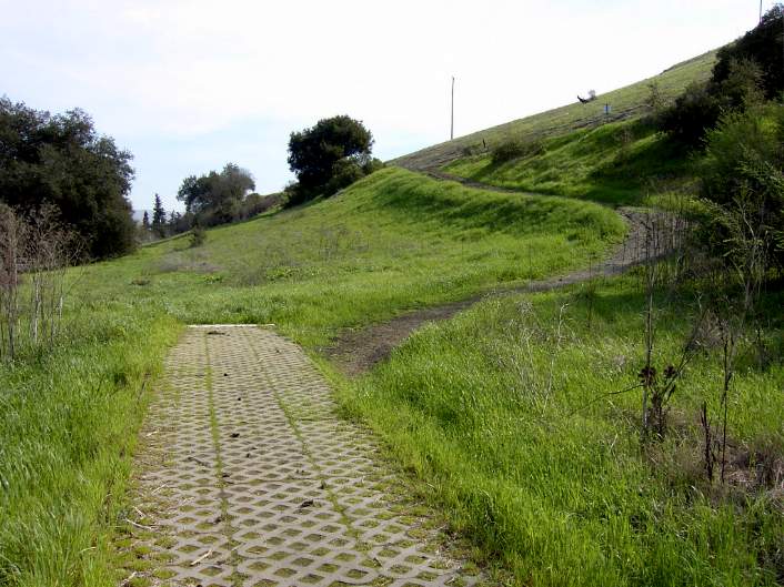 The
paved path below Santa Teresa Spring ends abruptly. An informal
dirt
path leads up to the Coyote-Alamitos Canal. There are no signs or
fences
at the start of the canal, which ends in a siphon before Santa Teresa
Spring.
The
paved path below Santa Teresa Spring ends abruptly. An informal
dirt
path leads up to the Coyote-Alamitos Canal. There are no signs or
fences
at the start of the canal, which ends in a siphon before Santa Teresa
Spring.
 This
is the Coyote-Alamitos Canal to the east of Santa Teresa Spring. A
fence blocks access to the further passage along the canal. Below the
fence
is the back of the Bear Tree Lot. A little farther along is the Pyzak
Ranch.
This
is the Coyote-Alamitos Canal to the east of Santa Teresa Spring. A
fence blocks access to the further passage along the canal. Below the
fence
is the back of the Bear Tree Lot. A little farther along is the Pyzak
Ranch.
 The
left side of the gate has a well-worn path, which people have used
to get around it. At this point, the canal belongs to the Santa Clara
Valley
Water District. The land above and below it belong to Santa Teresa
Park.
The canal continues behind the Bear Tree Lot, Pyzak Ranch, and Bonetti
House, then turns at San Ignacio and Heaton Moor. It then runs behind
houses
on Heaton Moor, where it becomes private property. (Note: since this
picture was taken, the gate has fallen down.)
The
left side of the gate has a well-worn path, which people have used
to get around it. At this point, the canal belongs to the Santa Clara
Valley
Water District. The land above and below it belong to Santa Teresa
Park.
The canal continues behind the Bear Tree Lot, Pyzak Ranch, and Bonetti
House, then turns at San Ignacio and Heaton Moor. It then runs behind
houses
on Heaton Moor, where it becomes private property. (Note: since this
picture was taken, the gate has fallen down.)
The Bear Tree Lot, Pyzak Ranch Area
 This
is Curie Drive eastbound just before the Bear Tree lot. Curie is a
wide street with sidewalk and room for bicycles on both sides, though
there
are no bike lanes.
This
is Curie Drive eastbound just before the Bear Tree lot. Curie is a
wide street with sidewalk and room for bicycles on both sides, though
there
are no bike lanes.
 This is
the dirt shoulder along Curie Drive at the edge of the Bear Tree
Lot. The sidewalk on the south side ends here. At the end of the Bear
Tree
Lot is the driveway to the Pyzak Ranch. Behind that is a wooden fence.
The Pyzak house is now being used as a park employee residence. The
Pyzak
Ranch house was originally Jacoba Bernal's House, built by Pedro
Bernal,
later occupied by the Fishers, the Browns, then Pyzak.
This is
the dirt shoulder along Curie Drive at the edge of the Bear Tree
Lot. The sidewalk on the south side ends here. At the end of the Bear
Tree
Lot is the driveway to the Pyzak Ranch. Behind that is a wooden fence.
The Pyzak house is now being used as a park employee residence. The
Pyzak
Ranch house was originally Jacoba Bernal's House, built by Pedro
Bernal,
later occupied by the Fishers, the Browns, then Pyzak.
 This
is the monument at the Bear Tree Lot explaining its history. The
monument
was placed there by the Clampers. The Bear Tree Lot is now closed to
public
access. The Coyote-Alamitos Canal runs along the lower hillside in back
of the lot. There is now no parking allowed in front of the monument.
There was a problem with homeless people camping out here in their cars
overnight.
This
is the monument at the Bear Tree Lot explaining its history. The
monument
was placed there by the Clampers. The Bear Tree Lot is now closed to
public
access. The Coyote-Alamitos Canal runs along the lower hillside in back
of the lot. There is now no parking allowed in front of the monument.
There was a problem with homeless people camping out here in their cars
overnight.
 This
is
Curie Drive at the start of the Pyzak Ranch's wooden fence. The
road is considerably narrower. Here, cars can park on the side of the
road,
and neighbors can leave yard clippings in the road, further narrowing
it.
This
is
Curie Drive at the start of the Pyzak Ranch's wooden fence. The
road is considerably narrower. Here, cars can park on the side of the
road,
and neighbors can leave yard clippings in the road, further narrowing
it.
 Ahead
is the corner of Curie and San Ignacio. There is no parking along
the north side of the road, though sometimes the neighbors leave yard
and
tree clippings in the street for recycling. There is an old barbed wire
fence along the field here, which was once a paddock. The fence at the
Bernal School field is just ahead across San Ignacio. The narrowing of
the street, the heavy traffic along the road, and the barbed wire fence
present hazards to bicyclists travelling to Bernal School or between
different
parts of Santa Teresa Park. It is unsafe for pedestrians to be on this
side, but for pedestrians travelling along the south side of Curie near
the Bear Tree lot, they must dart across the road, which has no nearby
crosswalks, to reach the sidewalk on the north side.
Ahead
is the corner of Curie and San Ignacio. There is no parking along
the north side of the road, though sometimes the neighbors leave yard
and
tree clippings in the street for recycling. There is an old barbed wire
fence along the field here, which was once a paddock. The fence at the
Bernal School field is just ahead across San Ignacio. The narrowing of
the street, the heavy traffic along the road, and the barbed wire fence
present hazards to bicyclists travelling to Bernal School or between
different
parts of Santa Teresa Park. It is unsafe for pedestrians to be on this
side, but for pedestrians travelling along the south side of Curie near
the Bear Tree lot, they must dart across the road, which has no nearby
crosswalks, to reach the sidewalk on the north side.
San Ignacio to Heaton Moor Drive
 This
is the field at Curie and San Ignacio. This was part of the old
Bonetti
Ranch. In the back of the field is the house originally built by Pedro
Bernal and later occupied by the Bonetti Family. It is now a park
employee
residence. To the left, across San Ignacio, is Bernal Intermediate
School.
The plans for this field call for it to be used for parking. It can be
used as a staging area to access a new trail leading to the Mine Trail.
The Coyote-Alamitos Canal runs along the hill behind the house.
This
is the field at Curie and San Ignacio. This was part of the old
Bonetti
Ranch. In the back of the field is the house originally built by Pedro
Bernal and later occupied by the Bonetti Family. It is now a park
employee
residence. To the left, across San Ignacio, is Bernal Intermediate
School.
The plans for this field call for it to be used for parking. It can be
used as a staging area to access a new trail leading to the Mine Trail.
The Coyote-Alamitos Canal runs along the hill behind the house.
 San
Ignacio turns left and becomes Heaton Moor Drive. Along the road is
a field below the Coyote-Alamitos Canal, which runs along the base of
the
hills. This is a possible entry/exit point for a new trail along the
Coyote-Alamitos
Canal before it turns into private property.
San
Ignacio turns left and becomes Heaton Moor Drive. Along the road is
a field below the Coyote-Alamitos Canal, which runs along the base of
the
hills. This is a possible entry/exit point for a new trail along the
Coyote-Alamitos
Canal before it turns into private property.
 This
is the beginning of private property along Heaton Moor. The
Coyote-Alamitos
Canal, which is private, runs in the hills above it.
This
is the beginning of private property along Heaton Moor. The
Coyote-Alamitos
Canal, which is private, runs in the hills above it.
 These
are the house on Norred Court. A bypass trail could run along or
over the hill behind these houses. Higher up on Bernal Hill, near the
PG&E
power towers, is the Bernal Hill Loop Trail.
These
are the house on Norred Court. A bypass trail could run along or
over the hill behind these houses. Higher up on Bernal Hill, near the
PG&E
power towers, is the Bernal Hill Loop Trail.
 This
is
the entrance to the Mounted Ranger Unit at Brockenhurst Drive off
Heaton Moor. This was not an official park entrance. People did use it
as an entrance until some neighbors complained, and it was closed. The
signs behind
the
gate said "Area Closed, No Entry, Service Vehicles Only." There are
homes
to the left and right of the entrance. In September 2006, after
petitions were circulated requesting it to be opened to the public,
this became an official entrance. It's a neighborhood entrance, not a
major staging area. Vehicles are not allowed to enter.
This
is
the entrance to the Mounted Ranger Unit at Brockenhurst Drive off
Heaton Moor. This was not an official park entrance. People did use it
as an entrance until some neighbors complained, and it was closed. The
signs behind
the
gate said "Area Closed, No Entry, Service Vehicles Only." There are
homes
to the left and right of the entrance. In September 2006, after
petitions were circulated requesting it to be opened to the public,
this became an official entrance. It's a neighborhood entrance, not a
major staging area. Vehicles are not allowed to enter.
Buck Norred Ranch Site/Mounted Ranger Unit
Many people in the area remember renting horses at the Buck Norred Ranch and riding them through the hills. There were also group parties and picnics held there. Buck Norred sold his ranch in the 1990's. Part of it along Heaton Moor was developed into housing. The rest was acquired by the county, but was left undeveloped for years. After hearing complaints about vandalism and illegal activities at the ranchsite, the County installed the Mounted Ranger Unit, which is now its official name. The facility began operation in 2002. While the rangers are stationed at Santa Teresa, they patrol all the county parks with their horses. Along with the rangers, who work there during the day, there is a camp host livng at the site in a trailer, providing 24-hour coverage for the area. This
is the service road leading up the hill to the west side of the Mounted
Ranger Unit. This road leads to a pavilion and an old barn. Just ahead
is the gate blocking access to the Coyote-Alamitos Canal. Part of this
road and the Coyote-Alamitos Canal are private property, belonging to
the
adjacent residents. (Note these pictures were taken before the area was
signed as being closed. It is now fenced off, and the road up the hill
has been torn up.)
This
is the service road leading up the hill to the west side of the Mounted
Ranger Unit. This road leads to a pavilion and an old barn. Just ahead
is the gate blocking access to the Coyote-Alamitos Canal. Part of this
road and the Coyote-Alamitos Canal are private property, belonging to
the
adjacent residents. (Note these pictures were taken before the area was
signed as being closed. It is now fenced off, and the road up the hill
has been torn up.)
 This
is
a view looking down from the access road. The gated Coyote-Alamitos
Canal is below. Below that are the houses whose owners also own the
canal
and some of the land above it.
This
is
a view looking down from the access road. The gated Coyote-Alamitos
Canal is below. Below that are the houses whose owners also own the
canal
and some of the land above it.
 This
is a view farther up the access road looking west along the hills
and down the Coyote-Alamitos Canal. Another gate can be seen along the
canal, along with the houses below it.
This
is a view farther up the access road looking west along the hills
and down the Coyote-Alamitos Canal. Another gate can be seen along the
canal, along with the houses below it.
 This is the
small seasonal creek that runs behind the ranch house.
This is the
small seasonal creek that runs behind the ranch house.
 This is
the old Buck Norred Ranch House. Prior to Buck Norred, the house
was owned by Herschel Johnson, then the Andersen family. The house is
boarded
up and has suffered from vandalism and trespassing in the years between
its sale by Buck Norred and the opening of the Mounted Ranger Unit in
2002.
Volunteers have painted out much of the graffiti. The ultimate fate of
the house is still uncertain.
This is
the old Buck Norred Ranch House. Prior to Buck Norred, the house
was owned by Herschel Johnson, then the Andersen family. The house is
boarded
up and has suffered from vandalism and trespassing in the years between
its sale by Buck Norred and the opening of the Mounted Ranger Unit in
2002.
Volunteers have painted out much of the graffiti. The ultimate fate of
the house is still uncertain.
 On 9/27/03, the Friends of Santa Teresa
Park helped with the open house
at the Mounted Ranger Unit. Here Mike Boulland is addressing neighbors,
park officials, and rangers.
On 9/27/03, the Friends of Santa Teresa
Park helped with the open house
at the Mounted Ranger Unit. Here Mike Boulland is addressing neighbors,
park officials, and rangers.
 The rangers gave a tour of the barn
facilities during the open house. The
visitors were allowed to tour the facilities, which are normally not
open
to the public.
The rangers gave a tour of the barn
facilities during the open house. The
visitors were allowed to tour the facilities, which are normally not
open
to the public.
 Here
are some of the buildings of the Mounted Ranger Unit. The main stables
are ahead. Behind it is the old barn, which has not been restored.
Here
are some of the buildings of the Mounted Ranger Unit. The main stables
are ahead. Behind it is the old barn, which has not been restored.
 This
is the honeymoon cottage. Compare this to the
picture above from 2001.
This
is the honeymoon cottage. Compare this to the
picture above from 2001.
 In the back of the facility is a
training
rink and fields. The facilities
extend back into the valley. The remnants of an old Buck Norred Ranch
riding
trail can be seen on the hillside to the left.
In the back of the facility is a
training
rink and fields. The facilities
extend back into the valley. The remnants of an old Buck Norred Ranch
riding
trail can be seen on the hillside to the left.
 Hikers
can be seen on the Mine Trail going up the hill behind one of the
buildings of the Mounted Ranger Unit. The RV belongs to the camp host
who
lives at the site and whose presence is one of the reasons that
vandalism
has ceased in this area.
Hikers
can be seen on the Mine Trail going up the hill behind one of the
buildings of the Mounted Ranger Unit. The RV belongs to the camp host
who
lives at the site and whose presence is one of the reasons that
vandalism
has ceased in this area.
 An
old trail runs below the Mine Trail and along the east edge of the
Mounted
Ranger Unit.
An
old trail runs below the Mine Trail and along the east edge of the
Mounted
Ranger Unit.
The Mine Trail
 This is
the start of the Mine
Trail at the Mounted Ranger Unit. The large interpretive sign warns
of mountain lions. To the left is a path
leading
up to the Coyote-Alamitos Canal levee road above a siphon. The canal
levee
is not an official trail. The Mine Trail here is an old asphalt ranch
road
that climbs steeply up the hill into the park.
This is
the start of the Mine
Trail at the Mounted Ranger Unit. The large interpretive sign warns
of mountain lions. To the left is a path
leading
up to the Coyote-Alamitos Canal levee road above a siphon. The canal
levee
is not an official trail. The Mine Trail here is an old asphalt ranch
road
that climbs steeply up the hill into the park.
The Mine Trail is the main trail artery for Santa Teresa Park. It is one of the longest, most popular, and most important trails in the park. It is a wide multi-use trail that is popular with bicyclists, hikers, and equestrians. Trail users can take it to access most of the park's trails. It eventually ends up at the Pueblo Day Use Area in the heart of the park. For part of its length, the Mine Trail is a segment in the Bay Area Ridge Trail. It is also part of the Juan Bautista de Anza National Historic Trail system.
From the Mounted Ranger Unit, the Mine Trail goes uphill to a junction with the Hidden Springs Trail, which runs up to a trailhead at Bernal Road. It continues uphill through oak forests and intersects the end of the Bernal Hill Loop Trail. It crosses Bernal Road, where the Pueblo Trail branches off to the left. Nearby is a tiny free parking lot near the entrance to the IBM Almaden Research Center. The Mine Hill Trail then goes downhill along Trench Hill and meets the end of the Stile Ranch Trail, at which point it becomes part of the Bay Area Ridge Trail. It goes uphill, then downhill to join up with the start of the Fortini Trail. It turns back towards the center of the park, crosses a marsh by an old corral, at which point the Rocky Ridge Trail branches off to the right. It then hits the parking lot and corral at the end of the Pueblo Area, continuing on behind it until it ends at the Hidden Springs Trail, which leads up to Coyote Peak. Parking at the Pueblo Area requires a fee, which is why many people prefer to access the trail from Brockenhurst or from Bernal Road.
 This is a
view from the Mine Trail looking down towards its trailhead at
the Mounted Ranger Unit. To the left is a recently-built corral for
horses.
This is a
view from the Mine Trail looking down towards its trailhead at
the Mounted Ranger Unit. To the left is a recently-built corral for
horses.
 This
is where
the Hidden Springs Trail crosses Bernal Road. Trail users can up
Bernal
Road from the park entrance to reach this point. The Hidden Springs
Trail
drops down a short distance and joins the Mine Trail.
This
is where
the Hidden Springs Trail crosses Bernal Road. Trail users can up
Bernal
Road from the park entrance to reach this point. The Hidden Springs
Trail
drops down a short distance and joins the Mine Trail.
 This
is a view from an oak grove on the Mine Trail. Bernal Road cuts across
the hill in the background. The Mine Trail is a shadier alternative to
Bernal Road.
This
is a view from an oak grove on the Mine Trail. Bernal Road cuts across
the hill in the background. The Mine Trail is a shadier alternative to
Bernal Road.
 This
is the junction of the Bernal Hill Loop Trail and the Mine Trail.
This
is the junction of the Bernal Hill Loop Trail and the Mine Trail.
 At the
top
of Trench Hill by the small parking lot, the Mine Hill trail
crosses Bernal Road and continues on the other side. The Mine Trail
drops
down and meets the Stile Ranch Trail at the bottom of the valley ahead,
at which point it becomes part of the Bay Area Ridge Trail.
At the
top
of Trench Hill by the small parking lot, the Mine Hill trail
crosses Bernal Road and continues on the other side. The Mine Trail
drops
down and meets the Stile Ranch Trail at the bottom of the valley ahead,
at which point it becomes part of the Bay Area Ridge Trail.
 The
Mine
Trail drops down to meet the Fortini Trail, which runs to the
right. Ahead in the distance is Big Oak Valley and the Rocky Ridge
Trail.
The Mine Trail heads to the left and goes into the Pueblo Area.
The
Mine
Trail drops down to meet the Fortini Trail, which runs to the
right. Ahead in the distance is Big Oak Valley and the Rocky Ridge
Trail.
The Mine Trail heads to the left and goes into the Pueblo Area.
Coyote-Alamitos Canal to Bernal Road
 Just
to the left of the Mine Trail entrance is the gated access road to
the Coyote-Alamitos Canal levee. While this is not
an official trail and belongs to the Water District, this is
frequently-used
as a trail. The park map specifically says this is not a trail.
Technically,
those using it are trespassing on Water District property, though they
are seldom cited. A short section of the canal levee is directly behind
some homes. After that, it runs above a long greenbelt, which is part
of
Santa Teresa Park. (Note: a larger fence is now in place blocking
access to the canal.)
Just
to the left of the Mine Trail entrance is the gated access road to
the Coyote-Alamitos Canal levee. While this is not
an official trail and belongs to the Water District, this is
frequently-used
as a trail. The park map specifically says this is not a trail.
Technically,
those using it are trespassing on Water District property, though they
are seldom cited. A short section of the canal levee is directly behind
some homes. After that, it runs above a long greenbelt, which is part
of
Santa Teresa Park. (Note: a larger fence is now in place blocking
access to the canal.)
 This
is
the end of the Coyote-Alamitos Canal on Bernal Road. For a long time,
there were
no fences or "no trespassing" signs to prevent entry. The only signs on
the canal said "no vehicles." Now, a fence and gate, posted with "no
trespassing" signs blocks the entrance. Along the way are unofficial
footpaths
leading
up to it. Another unofficial trail leads up from the canal levee and
joins
with the Mine Trail partway up the hill. On the opposite side of Bernal
Road, a short stretch of the canal levee leads to access to the Ohlone
Trail and the Laurel Canyon Nature Trail. The canal goes into the Santa
Teresa Golf Course, but a fence blocks further travel for trail users
outside
the golf course. The canal runs through the golf course, then emerges
at
the other end by the archery range, where it runs behind range targets.
This
is
the end of the Coyote-Alamitos Canal on Bernal Road. For a long time,
there were
no fences or "no trespassing" signs to prevent entry. The only signs on
the canal said "no vehicles." Now, a fence and gate, posted with "no
trespassing" signs blocks the entrance. Along the way are unofficial
footpaths
leading
up to it. Another unofficial trail leads up from the canal levee and
joins
with the Mine Trail partway up the hill. On the opposite side of Bernal
Road, a short stretch of the canal levee leads to access to the Ohlone
Trail and the Laurel Canyon Nature Trail. The canal goes into the Santa
Teresa Golf Course, but a fence blocks further travel for trail users
outside
the golf course. The canal runs through the golf course, then emerges
at
the other end by the archery range, where it runs behind range targets.
 This
is a field at the entrance to the park on Bernal Road. It is a flat
area that could be used for a parking lot and staging area to reduce
parking
by park users in front of the houses along Heaton Moor and Bernal Road.
This
is a field at the entrance to the park on Bernal Road. It is a flat
area that could be used for a parking lot and staging area to reduce
parking
by park users in front of the houses along Heaton Moor and Bernal Road.
Fence Above the Coyote-Alamitos Canal
On June 1, 2004, Deputy Park Director Joe Schultz visited the Mounted Ranger Unit with fence contractors and representatives of the Santa Clara Water District to discuss putting a fence around the areas of the Coyote-Alamitos Canal which are private property. Here Joe
Schultz is conferring with fence contractors, while Dale Honda
from the Water District is talking with one of the homeowners. Below
them
will be a new gate along the private property boundary, which will
still
allow the Water District to access the canal levee.
Here Joe
Schultz is conferring with fence contractors, while Dale Honda
from the Water District is talking with one of the homeowners. Below
them
will be a new gate along the private property boundary, which will
still
allow the Water District to access the canal levee.
 This is a
view from the old paved ranch road at the west end of the Norred
Ranch. The wooden stakes with the red flags are survey markers that
mark
the limits of private property. This part of the road is also private.
A round wire fence will enclose the private property and follow the
boundary
up to the clump of poison oak ahead. The old road will be removed and
the
ground will be disked. This road is no longer needed. There is a
service
road coming up from the back side to reach the buildings at the top of
the hill.
This is a
view from the old paved ranch road at the west end of the Norred
Ranch. The wooden stakes with the red flags are survey markers that
mark
the limits of private property. This part of the road is also private.
A round wire fence will enclose the private property and follow the
boundary
up to the clump of poison oak ahead. The old road will be removed and
the
ground will be disked. This road is no longer needed. There is a
service
road coming up from the back side to reach the buildings at the top of
the hill.
 Along the
canal above the houses, one of the homeowners has posted "Private
Property" signs.
Along the
canal above the houses, one of the homeowners has posted "Private
Property" signs.
 At the west
end of the group of houses along Heaton Moor, the Water District
recently erected a new gate on the canal. A new fence will go up the
hill
on the other side of the canal to show the private property boundary.
The
homeowner in the picture also owns the land from the gate down to
Heaton
Moor. This patch of land will be fenced off with a new gate.
At the west
end of the group of houses along Heaton Moor, the Water District
recently erected a new gate on the canal. A new fence will go up the
hill
on the other side of the canal to show the private property boundary.
The
homeowner in the picture also owns the land from the gate down to
Heaton
Moor. This patch of land will be fenced off with a new gate.
Trail Routes Around the Mounted Ranger Unit
These pictures below show the trails and areas around the Mounted Ranger Unit, as well as areas of concern. (Note, these pictures are large.) This
is a view of the Buck Norred Ranch Site from the Bernal Hill Loop
Trail. The Mine Trail is shown in orange. The blue dots show the lower
trailhead at the Mounted Ranger Unit and Hidden Springs Trail junction.
The Hidden Springs Trail is in blue. Bernal Road is in red. Until the
Brockenhurst entrance was re-opened the only
legal
way to reach the lower Mine Hill Trail was to go up Bernal Road to the
Hidden
Springs Trail junction.
This
is a view of the Buck Norred Ranch Site from the Bernal Hill Loop
Trail. The Mine Trail is shown in orange. The blue dots show the lower
trailhead at the Mounted Ranger Unit and Hidden Springs Trail junction.
The Hidden Springs Trail is in blue. Bernal Road is in red. Until the
Brockenhurst entrance was re-opened the only
legal
way to reach the lower Mine Hill Trail was to go up Bernal Road to the
Hidden
Springs Trail junction.
 This
is a closeup of the Mine Trail and the Mounted Ranger Unit below it.
The Mine Trail is shown in yellow. The Coyote-Alamitos Canal (not a
trail)
is shown in red. An old Buck Norred Ranch trail is shown in orange,
which
could be used as a trail to skirt around the Mounted Ranger Unit.
This
is a closeup of the Mine Trail and the Mounted Ranger Unit below it.
The Mine Trail is shown in yellow. The Coyote-Alamitos Canal (not a
trail)
is shown in red. An old Buck Norred Ranch trail is shown in orange,
which
could be used as a trail to skirt around the Mounted Ranger Unit.
 This shows
the areas of concern. The Coyote-Alamitos Canal, which disappears
under the Buck Norred Ranch Site in a siphon, is shown in red. Homes
along
Heaton Moor Drive run along the edge of the ranch site. The only
entrance
to the site is at Brockenhurst Drive. An old service road can be seen
in
the lower part of the picture running to the old pavilion and barn.
This shows
the areas of concern. The Coyote-Alamitos Canal, which disappears
under the Buck Norred Ranch Site in a siphon, is shown in red. Homes
along
Heaton Moor Drive run along the edge of the ranch site. The only
entrance
to the site is at Brockenhurst Drive. An old service road can be seen
in
the lower part of the picture running to the old pavilion and barn.
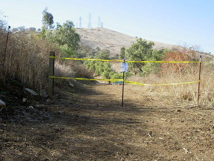
The New Norred Trail
(Updated 1/25/07)
After many meetings, public disclosures, plans, studies, and reviews,
in September 2006, the County Board of Supervisors approved the new
trail between the Bernal-Gulnac-Joice Ranch and the Mounted Ranger
Unit. In November, trail construction began. The Sweco bulldozer cut
the trail in only a few days. It was covered with straw and closed for
the winter to allow it to settle in. It will re-open in June 2007.
People who use the trail while it's closed may be cited.
The trail begins off the Joice Trail, partway up the hill and
above the Coyote-Alamitos Canal. It runs along the hillside with little
change in altitude until it reaches the Buck Norred Ranch site. Then it
drops down to the level of the Mounted Ranger Unit, running behind it
at the end of the valley. It follows along the hills a little above the
Mounted Ranger Unit, then joins up with the Mine Trail at about the
same level as the Coyote-Alamitos Canal. The Coyote-Alamitos Canal is
not an official trail and is fenced off.
The new trail was going to be called the "Los Alamitos Trail."
However, after reading the park's master plan, it was found that this
trail was
referred to as the "West Norred Trail." Since there is no "East Norred
Trail," it was decided to name this just the "Norred
Trail."
The Brockenhurst Drive entrance is now officially a
neighborhood entrance to the park. The signs have been changed to list
the park hours. The gate will be changed to an electric gate with a
self-closing hiker's gate on the side. The Mounted Ranger Unit is still
off-limits, but visitors can take the access road to the head of the
Mine Trail.
Here are some pictures of the new trail:
 Looking
down from the Joice Trail, the entrance to the Norred Trail on the
right.
Looking
down from the Joice Trail, the entrance to the Norred Trail on the
right.
 This is
the start of the trail on the day it was being constructed, 11/2/06.
This is
the start of the trail on the day it was being constructed, 11/2/06.
 You can
see the Sweco bulldozer cutting the trail on the hill above Santa
Teresa Spring.
You can
see the Sweco bulldozer cutting the trail on the hill above Santa
Teresa Spring. Here's a
closer view of the Sweco on the hillside.
Here's a
closer view of the Sweco on the hillside.
 The
trail was covered with straw and closed to the public shortly after it
was opened. (Taken 12/8/06.)
The
trail was covered with straw and closed to the public shortly after it
was opened. (Taken 12/8/06.)
 This is
a closeup of the trail signs announcing that the trail is closed.
This is
a closeup of the trail signs announcing that the trail is closed. The trail
cuts across the hillside above Santa Teresa Spring.
The trail
cuts across the hillside above Santa Teresa Spring. View of
the trail on the hillside above Heaton Moor.
View of
the trail on the hillside above Heaton Moor. View of
the trail above the houses around Norred Court. You can see the
construction crew on the trail (11/6/06).
View of
the trail above the houses around Norred Court. You can see the
construction crew on the trail (11/6/06).  View of
the hills west of the Mounted Ranger Unit. The trail descends here
following old ranch roads.
View of
the hills west of the Mounted Ranger Unit. The trail descends here
following old ranch roads.
 The
trail skirts around the rear of the Mounted Ranger Unit and runs along
the base of the hillside, parallel to the service road. (This picture
and 2 below taken from the horse paddocks by the Mine Trail.)
The
trail skirts around the rear of the Mounted Ranger Unit and runs along
the base of the hillside, parallel to the service road. (This picture
and 2 below taken from the horse paddocks by the Mine Trail.)
 You can
see the new trail running along the base of the hill, just above the
service road.
You can
see the new trail running along the base of the hill, just above the
service road.
 The
trail runs above and behind the Mounted Ranger Unit facilities. The
building in the foreground is used as an office by the rangers.
The
trail runs above and behind the Mounted Ranger Unit facilities. The
building in the foreground is used as an office by the rangers.
 The
trail turns a corner as it is about to join the Mine Trail.
The
trail turns a corner as it is about to join the Mine Trail.
 This is
the trailhead just off the Mine Trail. The entrance is closed until
June. (Taken 12/7/06.)
This is
the trailhead just off the Mine Trail. The entrance is closed until
June. (Taken 12/7/06.)
 This is
looking up the Mine Trail from the trailhead. To the left, the fence
blocks access to the Coyote-Alamitos Canal. The Norred Trail entrance
is on the right, across from where the fence ends.
This is
looking up the Mine Trail from the trailhead. To the left, the fence
blocks access to the Coyote-Alamitos Canal. The Norred Trail entrance
is on the right, across from where the fence ends.
 This is
at the Brockenhurst Drive entrance to the Mounted Ranger Unit. The
trail above the houses can be seen on the hillside in the background.
This is
at the Brockenhurst Drive entrance to the Mounted Ranger Unit. The
trail above the houses can be seen on the hillside in the background.
Friends of Santa Teresa Park Links:
- Meeting on 5/6/04 discussing access around the Mounted Ranger Unit.
- Information on the Pyzak Ranch before it was purchased by the county.
- 2001 Pictures of the Buck Norred Ranch buildings before and after they were painted.
- Pictures of the park in 2001, including the Bernal-Gulnac-Joice Ranch and Buck Norred Ranch site
- Dedication of the Bernal-Gulnac-Joice Ranch, 6/29/02
- Tour of Rancho Santa Teresa
External Links:
- Community news from March 1, 1999 by Mike Boulland on the Buck Norred Site
- Community news from March 7, 1999 by Mike Boulland on the Buck Norred Site
- Santa Teresa Park History
- Santa Teresa Park map
- Santa Teresa Park Trails (including the Mine Trail, Joice Trail, Santa Teresa Spring)
- Bay Area Hiker: Santa Teresa County Park
- Bay
Area Ridge Trail
- Juan Bautista de Anza National Historic Trail
- Coyote-Alamitos Canal
- Santa Clara Valley Water District
- Santa Teresa Foothills Neighborhood Association
- Santa Clara County Horesmen's Association
- Santa Clara County District 1 (Don Gage)
- San Jose
Council District 2 (Ash Kalra)
- History San Jose