Open Space Authority Links:
Open Space Authority of Santa Clara Valley
OSA Board of Directors
Video: Your Open Space Lands in Santa Clara County, 5/15/14
Coyote Valley OSP Pictures:
Birding Hike in the Coyote Valley Open Space Preserve 11/8/14
Facebook: Nesting Knowledge: Coyote Valley Open Space Preserve, 4/4/15
Bay Nature Hike, Coyote Valley Open Space Preserve, 4/19/15
Coyote Valley Open Space Preserve Grand Opening, 6/27/15
Coyote Valley OSP LInks:
Coyote Valley Open Space Preserve Master Plan
2012
Coyote Valley Open Space Preserve Planning Recommendation 2/14/13
Gilroy Dispatch: Coyote Valley Property Does 180, 3/17/13
Coyote Valley Open Space Preserve Use and Management Plan 7/25/13
Coyote Valley Wildlife Linkage Assessment Project, 2013
Bay Nature Magazine article on Coyote Valley
Western Watershed Lands (includes Coyote Valley)
Mercury News: Bridge Building by Helicopter in Future Coyote Valley Preserve
Coyote Valley Open Space Preserve - Building Bridges Video, 2/17/15
Coyote Valley Trail Building Video 2/20/15
Coyote Valley Open Space: Wildlife Within Silicon Valley 6/23/15
Coyote Valley’s a hidden gem that must be seen 6/24/15
New park in Silicon Valley opens Saturday, rekindling debate over future of Coyote Valley
Open Space to celebrate grand opening of Coyote Valley Preserve June 27 6/26/15
San Jose Mayor Sam Liccardo: New era of conservation gaining momentum in Coyote Valley 6/27/15
Coyote Valley Open Space Preserve Grand Opening, video uploaded by Senator Jim Beall, 6/27/15
Rancho Canada Del Oro:
Rancho Canada Del Oro Open Space Preserve
Rancho Canada Del Oro Hike, 5/16/09
Rancho Canada Del Oro Hike, Mayfair Ranch Trail, 3/14/10
Facebook: Rancho Canada del Oro Hike, Mayfair Ranch Trail 1/18/14
Rancho Canada Del Oro (Pictures by Cait Hutnik)
Bird Count 2006: Rancho Canada Del Oro and Blair Ranch
Bay Nature Institute: Rancho Canada Del Oro
Blair Ranch Hike, 5/9/09
Blair Ranch Hike 3/28/10
Facebook: Rancho Canada del Oro Spring Flowers Before Spring Hike, 2/15/15
Facebook: Rancho Canada de Oro Docents Hike, 2/21/15
Facebook: Rancho Raptors: Big Birds of Prey at Rancho Canada del Oro 6/18/15
Coyote Ridge Links:
Coyote Ridge Wildflowers, 4/13/08
Coyote Ridge Wildflower Walks 4/18/10 and 4/3/10
Coyote Ridge, 4/18/10 (Facebook)
Coyote Ridge, April 17, 2011 (Facebook Album)
Coyote Ridge Wildflower Walk, 4/13/14
Facebook: Coyote Ridge Hike 4/13/14
Facebook: Coyote Ridge Hike by Open Space Authority Docents, 3/1/15
Coyote Ridge Wildflower Walk, 3/15/15
Light of Morn: Coyote Ridge
Light of Morn: Coyote Springs Wildflowers
Coyote Ridge Serpentine Grasslands Field Trip
Sierra Vista & Alum Rock Park Links:

Sierra Vista Open Space Preserve
Sierra Vista Map
Directions to Sierra Vista
Boccardo Loop Trail, 8/14/10
Sierra Vista Trail Dedication 10/22/11
Facebook: Sierra Vista Trail Dedication 10/22/11
Sam Drake's Pictures, Sierra Vista Hike 10/22/11
Ellen Finch's Pictures, Sierra Vista Hike 10/22/11
Sierra Vista Boccardo Trail Hike 8/14/10
Facebook: Sierra Vista Hike 11/23/12
Sierra Vista Staging Area Dedication 8/23/14
Aquila Trail Dedication 8/23/14
Meetup.com pictures, Sierra Vista Opening
Facebook: Sierra Vista Open Space Preserve Aquila Trail Winter Hike, 2/16/15
Facebook: Sierra Vista Open Space Preserve Sierra Vista Trail Winter Hike, 2/16/15
Facebook: Sierra Vista Boccardo Hill Views, 2/22/15
Facebook: Sunset & Moonrise at the Sierra Vista Open Space Preserve, 5/3/15
Other Open Space Authority Properties:
Doan Ranch Page 1, Page 2
Palassou Open Space Preserve Hike, 6/6/09
Melchor Ranch Docent Hike, 10/28/14
Melchor Ranch Public Hike, 11/1/14
Facebook: Doan Ranch Tour, 4/12/15
Facebook: Doan Ranch Satellite and 3D Maps
Urban Projects Partially Funded by the Open Space Authority:
The Albertson Parkway
Guadalupe River Trail Hwy 101 to Alviso (see Ulistac)
Facebook: Guadalupe River Trail to Ulistac Natural Area, 8/25/12
Facebook: San Tomas Aquino Creek Trail to 49'ers Stadium, 8/25/12
Facebook: Ulistac Natural Area, Santa Clara, 1/12/14
Facebook: Levi's Stadium, San Tomas Aquino Creek Trail, 8/2/14
San Tomas Aquino/Saratoga Creek Trail, Santa Clara (8/5/09-8/3/14)
Facebook: Stojanovich Family Park, Campbell 5/14/15
Bay Area Ridge Trail Links:
Bay Area Ridge Trail
Bay Area Ridge Trail Council's Facebook Page
Facebook, Goal: Hiking the Entire Bay Area Ridge Trail
Ridge Trail Guidebook
Ridge Trail, Sierra Vista map
Ridge Trail: Alum Rock and Boccardo Trail
KQED Quest on the Bay Area Ridge Trail
Mercury News: Santa Clara County: Lots of Trail, Lots of Gaps
Other Park and Trail Pages:
Ron Horii's SF Bay Rec & Travel
Santa Clara County Parks
Pictures of the Santa Clara County Parks
Guadalupe River Park and Gardens:
Guadalupe River Trail
Guadalupe Creek Trail
Coyote Creek Trail
Bay Area Biking
Los Alamitos Creek Trail
Bay Trails, South Bay
Bay Area Parks
Friends of Santa Teresa Park
Pictures of Santa Teresa County Park
Almaden Quicksilver Park
Harvey Bear Ranch-Coyote Lake Pictures, 3/10/07, 3/21-21/09, 4/18/09
Almaden Quicksilver Wildflowers and Views, Spring 2008, Part 2
The Penitencia Creek Trail
Penitencia Creek Trail, Bay Area Ridge Trail Dedication, 10/25/08
Uvas Canyon Healthy Trails Hike, 2/21/09
Ed Levin County Park, Monument Peak Trail 3/3/09
Healthy Trails Walk, Almaden Quicksilver 3/28/09
Healthy Trails Hike, Calero, 4/25/09
Rancho San Vicente Hike, 6/13/09
Joseph D. Grant County Park 1/31/10
POST Rancho San Vicente Hike, 4/10/10
Outdoor Photography/Wildflower Walk, Rancho San Vicente, 4/17/10
Rancho San Vicente Outdoor Docent Hike, 5/30/10
Rancho San Vicente hikes, 4/3/11 and 5/15/11
Coyote Peak Sign Dedication, Santa Teresa Park, 10/25/14
Coyote Peak to Rocky Ridge Hike and Views, 11/2/14, Santa Teresa County Park
Facebook: Rancho San Vicente POST Hike, 11/23/14
Facebook: Santa Clara County Parks Slideshow for the Hellyer Visitor Center, 3/11/15
Facebook: Santa Clara County Parks Slideshow, Additional Pictures, 3/11/15
Facebook: Wildflower Hike on the Stile Ranch, Mine, Fortini Trails, 3/14/15
Facebook: Hunt for Wildflowers and Butterflies in Santa Teresa Park 4/2/15
Arrowhead Loop Trail Hike in the Coyote Valley Open Space Preserve, 6/27/15
After
many years in the making, the Coyote Valley Open Space Preserve was
opened to the public on 6/27/15. It covers 348 acres in the north part
of the Coyote Valley. It is just south of the urbanized Silicon Valley
and is actually part of San Jose. It was purchased in 2010 for $3.5
million. There was an opening celebration, with information booths,
displays, games, and crafts for kids. There were speeches praising the
preservation of the land for public benefit. Afterwards, there were
guided hikes of the 4-mile Arrowhead Loop Trail in the park. While
there have been guided hikes of the preserve before it was open (see
the links on the left), this was the first one on the whole trail.

Mapboard at the entrance to the trails in the preserve.

Heart's Desire Trail in the flat meadow part of the preserve.

Interpretive sign talks about how nature has adapted to drought.

Ahead, the trail passes under ancient oak trees. The umbrellas and canopies are for the opening ceremonies.

This is the start of the Arrowhead Loop Trail at the south end. It's possible to take the trail loop clockwise or counter-clockwise. We took it clockwise.

Paul Billig, who has been to the preserve many times and has led hikes here, is the hike leader, accompanied by docents.


Paul talks about the different kinds of oak trees in the preserve. Above are blue oaks, with coast live oaks and valley oaks nearby.


Paul talks about the poison oak growing on this oak tree.

This is the view from that point. The hill in the center with the antenna and power towers is Coyote Peak in Santa Teresa County Park.

Looking back downhill, this is where the opening ceremonies were held. The flat meadow area covers about 26 acres. Next year, there will be an all-access trail around it.

We pass through a grove of bay laurels and California buckeye trees.

We stop at one of the scenic overlooks to check out the view.

There's a bench at the overlook, which provides a panoramic view of the Coyote Valley.

This sign at the overlook talks about the importance of preserving open space to provide wildlife corridors.

These
hills are in the adjacent ranch to the south of the preserve. This is
the 2,700-acre Tilton Ranch. The 348-acre parcel of Coyote Valley OSP
was once part of the Tilton Ranch, but it was sold to developers in
1993 to cover inheritance taxes. The downturn in the economy and
housing market prompted the developers to sell the land to OSA for a
fraction of its potential value.


Down below is Palm Avenue and the entrance to the preserve.

Running on top of the ridge across the valley is a service road that was used for hikes before the new trail was completed. It's steep in places and will not be used as a trail anymore.


There's a bench here for viewing this part of the hills.

This is the view from the bench.


Above is a string that marks the property line. The fence above it is within the adjacent private ranch.

This is the first of 5 bridges on the Arrowhead Loop Trail. It's right at the preserve boundary. The road on the hillside is in the adjacent private ranch.


We pass by a rocky cliff, which has a variety of wildflowers in the spring.

Down below, we can see the lower parts of the trail.

This is the second bridge.


We stop to look at a patch of sticky monkeyflowers.

The monkeyflowers attract hummingbirds, like this one.

As we go higher up, we can see the only major industrial development in the North Coyote Valley: IBM's Silicon Valley Lab on Bailey Avenue and the Metcalf Energy Center on Monterey Road (behind the hill).

Rock outcropping above the trail.

Trail junction to the scenic overlook.

This is the short trail that leads to the overlook. We skipped it in the interest of time.

We reach the old service road that runs along the ridgetop at the edge of the preserve. Adjacent to the preserve is this farm pond with an orchard and chicken coop. In the background are the hills of Rancho Canada del Oro and the ridgeline of the Sierra Azul Range.

This blue oak has colorful leaf galls on it.

We follow the old ranch road along the ridge.

These hay bales are intended to block off the steep service road that was used as a trail before the new trail was completed. They also provide a convenient place to sit, though they are probably temporary.


From the ridgeline, we catch a glimpse of Calero Reservoir. The green below is part of the Cinnabar Hills Golf Course. Hopefully someday there will be a link between Coyote Valley OSP and Calero County Park, which connects to Rancho Canada del Oro OSP.

This viewpoint of Calero is at he high point of the trail. We now begin to head downhill.


As
we head downhill, we get a better view of the North Coyote Valley, with
IBM's Silicon Valley Lab along Bailey Avenue on the left. Behind it is
Santa Teresa County Park. The hill slightly to the left of center is
Tulare Hill. At the foot of Tulare Hill on the right is the Metcalf
Energy Center. The open field below Tulare Hill was once slated to be a
major urban development that would have been filled with residences,
factories, and commercial businesses. This would have been a mini-city
with a population bigger than Mountain View. That plan fell through,
but that area is still subject to development.

This is a view looking across the Coyote Valley. Coyote Ridge is on the opposite side of the valley. The OSA leads wildflower hikes there in the springtime (see the links on the left).

Pointing out sights in the Coyote Valley. Note the bench by the trail.

The cuts in the hillside across the valley are part of the Kirby Canyon Landfill. The top of the ridge is protected. The tree-covered ridge behind it is Pine Ridge in Henry Coe State Park.

This shows the serpentine-covered hills in the preserve. They are sensitive areas with rare and endangered species on them, so there will be no trails or public access there.

The fence on the hill is the property line. To the left is private ranchland.


Wood rat's nest.

Funnel web spider.


This is at the westernmost corner of the preserve. The hills beyond are private property.

There are picnic tables ahead at a viewpoint.

Here, we can see the end of the trail at the left.


This is the third bridge.


Bridge #4.

A short distance from bridge #4 is bridge #5, the last one on the trail. We are almost at the end of the trail.

This is the end of the Arrowhead Loop Trail. We take the flat Heart's Delight Trail back to the start.
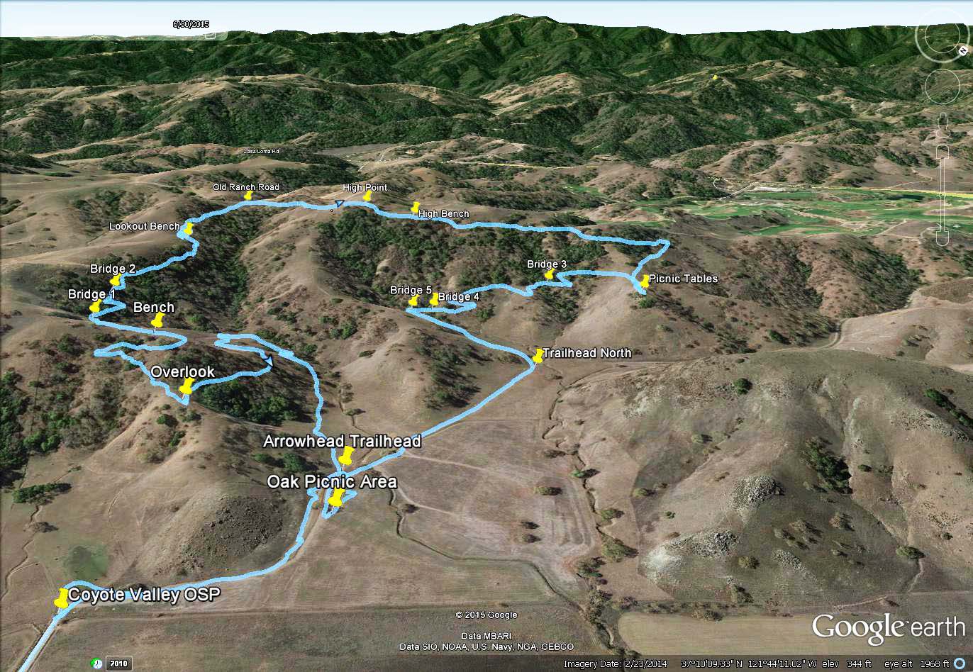
Google Earth GPS Tracks
I
hiked the trail with my GPS receiver and recorded my track on 6/29/15.
I took that
track, edited it, and imported it into Google Earth, along with
waypoints marking signicant points of interest along the trail. Below
are screen dumps from Google Earth, showing 3D satellite views of the
preserve and significant landmarks and points of interest in
surrounding areas. The GPS track in Coyote Valley is shown in light
blue. The pictures below are reduced in size. Click on them for a
larger version.
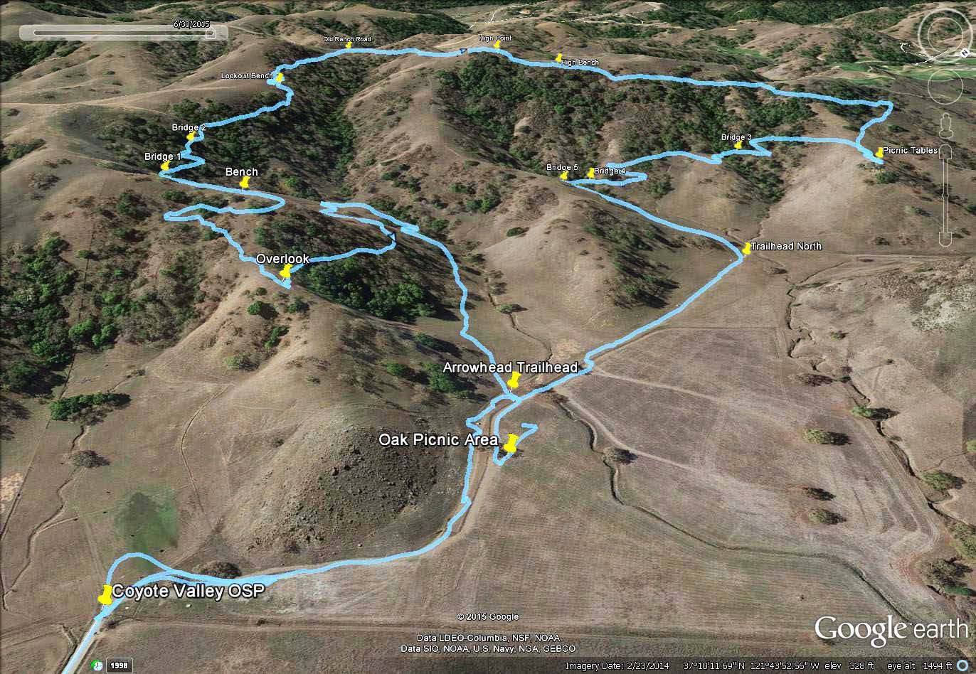
This is a view of the preserve looking southwest, with the Palm Avenue entrance and staging area on the lower left.

This is a view of the preserve looking southeast, with the northwest corner on the lower right.

This is a closer view of the start of the trail, from the south trailhead to the overlook and lookout bench. This shows how the trail gradually ascends the hill on switchbacks and goes deep into the valley.

This is a view looking northeast over the corner of the preserve where the new trail meets the old ranch road, looking down the long valley on the south part of the preserve.
This
is the southwest view zoomed out, showing the hill in the lower right,
half of which is in the preserve. In the background on the right is the
Cinnabar Hills Golf Course. In the hills behind it are Calero County
Park and Rancho Canada del Oro Open Space Preserve. The high ridge on
the horizon is the Sierra Azul Range, the northern part of which is in
Sierra Azul Open Space Preserve.

This is a view west from the above the high point of the trail, showing the Cinnabar Hills Golf Course next door and Calero County Park and Rancho Canada del Oro Open Space Preserve in the background.

This
is a view from above the Calero County Park office off McKean Road. In
the center is the Cinnabar Hills Golf Course. Part of the land north of
the golf course and across McKean Road from the Calero office is part
of Calero. It may be possible to connect Calero to Coyote Valley by
going around the golf course. In fact, the Calero County Park Trails
Master Plan map below shows the connection to Coyote Valley OSP on the
far right:


This is a view above Rancho Canada del Oro Open Space Preserve and Calero County Park. Calero and Canada del Oro are connected, so connecting Coyote Valley OSP to Calero will also connect it to Canada del Oro.

This
is a view looking northwest up the Coyote Valley from above Morgan
Hill. It shows how the Coyote Valley is just a small section of green
belt between 2 heavily urbanized areas, but surrounded on either side
by huge areas of undeveloped open space. It shows that it provides a
critical linkage for wildlife migration between the habitats in the
Diablo Range on the right and the Santa Cruz Mountains on the left.
Coyote Valley OSP is an important step in preserving that linkage.
Wildlife need to migrate to maintain genetic diversity, which helps
them survive environmental changes.
See more Google Earth maps in the Bay Nature Hike in the Coyote Valley Open Space Preserve, 4/19/15 webpage.
Here is the GPX track file and waypoints showing the hikes I made on 6/27 and 6/29/15. The track on the 27th is not complete.
Coyote
Valley Open Space Preserve is at the west end of Palm Avenue. To get
there from the north, take the Bailey Avenue exit from 101. Turn left
on Santa Teresa Blvd. Turn right on Palm Avenue to the preserve
entrance. To get there from Morgan Hill and points south, take 101 to
Cochrane. Go west to Monterey Road. Turn right. Turn left on Palm
Avenue. Follow it to the end.
Created
by Ronald Horii, 6/30/15,
updated 7/6/15