Links
Park Links
Ed Levin County Park
Ed Levin Park Map
Santa Clara County Parks
East Bay Regional Parks
Mission Peak Regional Preserve
Sunol Regional Wilderness
Ohlone Regional Wilderness
City of Milpitas Parks
Bay Area Ridge Trail
Wings of Rogallo Hang Gliding
Friends of Santa Teresa Park
Pictures of Ed Levin County Park, Milpitas, Hike to Monument Peak, March 3, 2009
The route taken below is open to hikers and equestrians only. The total distance is about 3.3 miles one way, but it requires an ascent of about 2000 feet. There are some steep hills to climb, but many switchbacks, so the ascent is not too strenuous. There is limited shade, but the breezes from the Bay help keep the hike from being too hot.

The trailhead for the Tularcitos Trail is behind the off-leash dog park.

Looking back down the Tularcitos Trail towards the dog park, above Sandy Wool Lake.

At the Agua Caliente Trail junction, looking south at the Spring Valley Golf Course.

View from the Aqua Caliente Trail of the service roads around the field used for hang glider landings.

Looking up the Agua Caliente Trail.

View of Sandy Wool Lake from the Agua Caliente Trail.

Approaching the hang glider access road. A windsock is on the hill to the left.

Hang gliders landing in the field
below. The Wings of Rogallo hang gliding club is allowed to fly hang
gliders and paragliders in the park. They have several launch points at
different elevations and use service roads to reach them.

The service road leading up to the hang glider launching area.

Water tank on the hill.

Hang glider soaring over the park.

View looking down at the hang glider access road crossing the Agua Caliente Trail.

Looking up the Agua Caliente Trail, which climbs up the steep hill in a series of switchbacks.

The Minnis Ranch Training Center, used by the County Parks, but not open to the public.

Looking up towards the hang glider launch site.
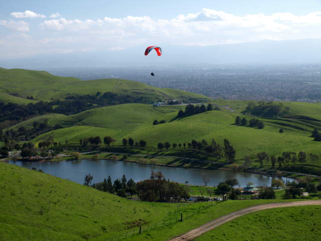
Hang glider soaring over Sandy Wool Lake.

The Agua Caliente levels off and follows along the hillside.

The trail nears a creek, marked by the line of trees.

Hikers descend the trail beyond the creek.

The creek area is very shady. It can be muddy.


Cows grazing on the hillside keep the grass short. They may be right on the trail, so approach carefully.

Hikers heading down the Agua Caliente Trail.

At the trail junction of the Agua Caliente Trail and the Monument Peak Trail.

Looking down at the junction of the Agua Caliente Trail (right) intersecting the lower part of the Monument Peak Road, which is a service road.

Looking up at the start of the Monument Peak Trail.

Cattle grazing above bikes on Monument Peak Road.

Monument Peak Road crosses the Monument Peak Trail. The service road is used to bring hang gliders to the top of the ridge. Hikers are advised not to use the road.

The Monument Peak Trail is hardly visible as it crosses through a cattle-grazed field.

Cattle gate on the Monument Peak Trail.

Turkeys on the hill.

Looking back down the Monument Peak Trail.

Shady ravine by the trail.

The trail runs through a shady oak forest.

The trail heading up the hill, running in and out of trees.

Looking back down the hill, the Monument Peak Trail can barely be seen running through the field. Monument Road can be easily seen above it.

The Monument Peak Trail heading up towards the Sierra Trail.

Rocks on the hill below Monument Peak.

The Sierra Trail leading south. It intersects Monument Peak Road.

The Sierra Trail heading towards Monument Peak.

As it was getting near sunset,
this was as close as I got to Monument Peak. The trail reaches Monument
Peak at 2594 feet. It then crosses into Alameda County and enters
Mission Peak Regional Preserve. After half a mile, it reaches the Bay
Area Ridge Trail, which descends the hill and re-enters Ed Levin as the
end of the Agua Caliente Trail. The Bay Area Ridge Trail route then
follow the Calera Creek Trail back to the park roads around Sandy Wool
Lake. Trails in Mission Peak Preserve lead to the trailhead at Stanford
Avenue, Ohlone College, Mission San Jose, and the Ohlone Wilderness
Trail.
The pictures below are from the return trip.

Cattle grazing on the Monument Peak Trail.

Wild turkeys grazing by the trail.

Looking down Monument Peak Road.

Cattle grazing below the Agua Caliente Trail.

Looking back along the Agua Caliente Trail before Monument Peak Road.

Moon above the Agua Caliente Trail.

Looking down at Sandy Wool Lake, with downtown San Jose in the distance.

Mustard on the hill above the Agua Caliente Trail.

Mustard, poppies, and the moon above the hills.

Looking back up the Agua Caliente Trail (same view as above near the start of the hike).

Looking down towards the end of the Agua Caliente Trail at the Tularcitos Trail junction.
Page created by Ronald Horii,
7/27/09