Links
Outdoor Photography
Outdoor Photo Gallery
Photo Class 2007 Powerpoint (21MB)
HDR Experiments-1
HDR Experiments-2
HDR Sunset Pictures at Hellyer Park
HDR Pictures at Uvas Canyon
Almaden Quicksilver HDR Pictures
Santa Teresa Pueblo Area HDR Sunset Pictures
HDR Norred Trail Sunset Pictures
Outdoor Photography Class, April 9, 2009
Sam Drake's Pictures of the 2009 Photo Class
Don Abel's Pictures of the 2009 Photo Class
HDR Uvas Canyon Waterfalls
Grant Ranch, 1/31/10
Outdoor Photo & Wildflower Walk, Rancho San Vicente, April 17, 2010
Outdoor Photography Class, Santa Teresa 10/2/10
Alviso Marina Sunset Pictures, 11/27/10
Stile Ranch Trail Sunset, 1/29/11
Rainbows, Santa Teresa Park, 1/30/11
Photography Class, Mummy Mountain Trail, 4/23/11
Photography Class, Mummy Mountain Trail, 4/7/12
Photography Class, Mummy Mountain Trail, 5/4/13
Coyote Lake Links
Coyote Lake/Harvey Bear Ranch County Park
Santa Clara County Parks
Mummy Mountain Trail Work Day/Trail Opening 4/24/10
Harvey Bear Ranch 3/10/07
Harvey Bear Ranch 3/20-21/09
Harvey Bear Ranch 4/18/09
Savannah Trail, Coyote Lake, 4/18/09
Sam Drake's Mummy Mountain Pictures on 2/6/10, 3/6/10,
Everytrail GPS Track and pictures: 2/6/10, 3/6/10
Kate Martin's photo gallery of the 4/24/10 Mummy Mountain Trail Event
Geocaching Class, Mummy Mountain Trail 5/15/10
Willow Springs, Savannah, Rancho San Ysidro Trails, 12/22/11
Roop Pond and Rancho La Polka Trails 2/20/12
Ed Willson Trail 11/10/12
Calaveras Trail Wildflowers, 4/9/13
Ed Willson Trail, 4/9/13
Other Park Links
Friends of Santa Teresa Park
Santa Teresa Park
Pictures of Santa Teresa County Park
Almaden Quicksilver County Park
Santa Clara County Parks
Pictures of the Santa Clara County Parks
Santa Clara County Parks Volunteer Activities
Santa Clara County Open Space Authority
Bay Area Ridge Trail
Henry Coe State Park
Other Park Pictures
Santa Teresa Park Wildflowers, Spring 2002
Mine, Fortini, Stile Ranch Wildflowers, 4/11/08
Coyote Peak, Rocky Ridge Wildflowers, Feb-Apr. '08
Coyote Ridge Wildflowers, 4/13/08
Almaden Quicksilver Wildflowers and Views, Spring 2008, Part 2
Bernal Hill wildflowers and views, Feb-Apr. '08 Part 1, Part 2
Coyote Peak, Rocky Ridge, Feb-April '08
Mother's Day Walk, Fortini-Stile, 5/4/08
Doan Ranch 11/22/08 Page 1, Page 2
Uvas Canyon Healthy Trails Hike, 2/21/09
Healthy Trails Walk, Almaden Quicksilver 3/28/09
Outdoor Photography Class/Wildflower Walk, Bernal Ranch/Hill 4/4/09
Geocaching Class, Fortini-Mine-Stile Ranch Trail, 4/11/09
Calero Healthy Trails Hike, 4/25/09
Pre-Mother's Day Walk, Fortini-Mine-Stile Ranch Trail, 5/3/09
Healthy Trails Walk, Fortini-Stile Ranch, 5/9/09
Blair Ranch Hike, 5/9/09
Rancho Canada Del Oro Hike, 5/16/09
Palassou Ridge 6/6/09
POST Rancho San Vicente Hike, June 13, 2009
Mt. Madonna Geocaching Class, 7/11/09
Hellyer HDR Pictures 1/10/10
Almaden Quicksilver Wood Road Geocaching Class 1/16/10
Uvas Canyon HDR Pictures 1/23/10
Joseph D. Grant County Park, 1/31/10
Uvas Canyon Hike, 2/13/10
Santa Teresa Park Sunset HDR Pictures 2/7/10
Rancho Canada Del Oro Hike, Mayfair Ranch Trail, 3/14/10
Blair Ranch Hike 3/28/10
POST Rancho San Vicente Hike, April 10, 2010
Rancho San Vicente Photography, Wildflower Hike, April 17, 2010
Coyote Ridge, 4/18/10
Pre-Mother's Day Hike, Santa Teresa Park, 5/2/10
Penitencia Creek Trail
Hellyer Festival in the Park, 6/26/10
Sierra Vista Open Space Preserve, Boccardo Trail, 8/14/10
Family Fandango 8/21/10
New Almaden Day, Junp-In Parade, 9/11/10
Spider Night, Bernal Ranch, 10/30/10
Rancho San Vicente, 4/3, 5/15/11
Woods Trail Wildflowers, Sierra Azul OSP 5/14, 5/2111
Almaden Quicksilver Pioneer Day, Casa Grande 11/13/10
REI Stile Ranch Trail Workday, 11/16/10
Hellyer Festival in the Park, 5/25/11
Family Fandango, 8/13/11
Pioneer Day, Outdoor Museum, Almaden Quicksilver 10/8/11
Sierra Vista Open Space Preserve Dedication 10/11/11
REI Stile Ranch Trail Workday 11/5/11
New Almaden, Buena Vista, Capehorn Pass, Hacienda Trails 1/27/12
Wildflower hike, Mine, Stile Ranch, Fortini Trails, 4/22/12
Hellyer Festival in the Park, 6/23/12
Villa Montalvo Trails, Villa and Gardens
Stevens Creek Healthy Trails Hike
New Almaden Day, Jump-In Parade, 9/8/12
Pioneer Day, Almaden Quicksilver 10/13/12, Incline Railroad Sign Dedication
Rancho San Vicente Hike 10/14/12
Los Alamitos-Calero Creek Trail, 12/24/12
Waterfall, Rainbow, and Clouds, 12/26/12
Coyote Peak Pictures, 12/27/12
Lichen Hike, Stile, Mine, Fortini Trails, 2/16/13
Santa Teresa Hidden Springs, Coyote Peak, Boundary, Rocky Ridge, 2/17/13
Hellyer Festival in the Park, 6/22/13
Campout Santa Teresa, Night Hike to Coyote Peak, 8/10/13
Pioneer Day, Almaden Quicksilver 10/12/13
Post-Thanksgiving Hike to Coyote Peak, 11/29/13 (Facebook)
Bernal Hill Hike, Santa Teresa Park, 12/8/13 (Facebook)
Archery Range, Santa Teresa Park, 2/22/14 (Facebook)
Coyote Ridge Wildflower Walk, 4/13/14
Outdoor Photography Class and Hike, Mummy Mountain Trail, Coyote Lake/Harvey Bear County Park, 5/3/14
On May 3, 2014, docent Ron Horii
gave an outdoor photography class at the Mendoza Ranch Staging Area at
Coyote
Lake/Harvey Bear Ranch County Park in Gilroy. See the links on
the left for more
information on outdoor photography and pictures of previous classes.
Ron
has been giving outdoor photography classes for several years. Fall
classes usually involve a Powerpoint slideshow in the Bernal Ranch Barn
at Santa Teresa Park, followed by a short outdoor walk. Spring classes
involve a shorter talk and a hike. This was Ron's fourth class
on the Mummy Mountain Trail. It is one of the most scenic trails in the
park, with a wide variety of terrain, panoramic views on both sides of
the ridge, wildflowers, and interesting sights along the trail.

This is Ron waiting at the Mendoza
Ranch staging area for the class to arrive (using a remote-controlled
camera on a tripod). At last year's class on May 4, the grasses were
dry, and there were few wildflowers left. This time, the
hills
are still green, and there are lots of wildflowers out. Here at the
trailhead are purple spring vetch and yellow hawksbeard. The Mummy
Mountain Trail runs up the ridge in the background.

These are the photo class attendees at the trailhead.

Along the way on the Mendoza Trail, we see green hills, yellow mustard, and the Roop Pond.

Under the shade of oak trees, Ron
talks about lighting in photography. He points out that the sunny
mid-day lighting they are experiencing now is the easiest for beginners
to take acceptable pictures, but the worst for taking good pictures.
The mix of sune and shade under the trees makes for challenging
lighting to capture the full dynamic range of the scene. He talks
about ways to get around that, including high dynamic range (HDR)
techniques. (Picture
courtesy of Paul Gardner.)

The group looks at the wildflowers along this shady part of the Mendoza Trail.

We reach the Mummy Mountain Trail and cross this trail bridge. Ron talks about how to use lines, like the rails of the bridge, to lead the eye into the picture.

These sandstone cliffs provide lots of interesting textures, colors, and plants.

These are bee plants. They have tiny red flowers that feed native bees. The orange-flowered plants to the left are sticky monkeyflowers.

The path wanders through this field of rough, colorful sandstone boulders, which provides interesting contrasts with the plants and trees.

Ahead, the trail crosses a meadow and switches back as it climbs up to the ridgetop.

There are miniature lupines along the hillsides, which are hard to see from a distance, but are colorful close up.

There are lots of purple spring vetch on the hillside.

The rest of the group ascends the hill.

These sunflowers on the hillside just below the ridgetop are balsamroots.

These balsamroots on the hillside below provide foreground interest in this shot, with the meadow in the mid-ground and Coyote Lake in the background.

The class reaches the ridgetop and gets panoramic views of Gilroy and San Martin.

The rest of the group reaches the ridgetop and takes in the view.

The trail runs along the center of the ridgeline.

On top of the ridge, next to the trail is this one bush with bright red, spikey fuchsia-flowered gooseberries.

There's a huge ancient bay laurel tree next to the trail.

There are lots of purple ithuriel's spears on the hill.

This part of the hill is covered with spring vetch and occasional hawksbeard.

There's a serpentine outcropping on the hilltop. The rocky soil is poor in nutrients that non-native grasses need to thrive, but native wildflowers are adapted to it. There are less grasses and more native wildflowers in the serpentine soil.

Here is a patch of bright red indian paintbrush.

The group takes pictures of the indian paintbrush.

These pink flowers are farewell-to-spring clarkia, which appear in late spring.

We approach the rest area near the summit of the trail.

We get a clear view of Coyote Lake from this point. The campground is below to the right of the lake.

We take a lunch break at the rest area by the summit.

This is near the high point of the trail, with views towards Morgan Hill.

The trail follows a narrow path along the ridgeline. There is a sticky monkeyflower bush on the right.

We come down the stone staircase, which is a bit over-grown.

The trail descends the steep hillside. Mummy Mountain got its name because it looks like a mummy lying on its back. We started the hike at the mummy's legs, walked along its chest, and are descending to its neck.

As the trail runs down along the hill, it reveals views of the rest of the park to the north.

As we descend this steep part of the trail, we can see where Coyote Creek forms a marsh as it flows into Coyote Lake. Coyote Creek is dry now.

These trees form a natural arch, framing the view of San Martin and Morgan Hill in the background.

This is the view from the mummy's "neck." Ahead on the right is its "chin." The view opens up to the north, all the way to Coyote Peak in Santa Teresa Park on the left.

This part of the hillside is covered with white Chinese houses, mixed in with spring vetch.

We cross along the side of the mummy's head. There are lots of buckeye blooming along the steep hillside, along with sticky monkeyflowers.

Here are mule's ear sunflowers and sticky monkeyflowers.

Against a background of Chinese houses are purple wild onions.

This is the north side of Mummy Mountain, the top of the mummy's head. It has the most wildflowers.

This deep blue flower is a larkspur.

Below, we can see the Coyote Ridge Trail on the right, with the Gaviota Trail leading off to the left.

There's one last switchback on the trail.

The Mummy Mountain Trail makes its last descent. The Mendoza Trail is below on the left.

This photographer is taking pictures of the flowers on the hill.

Here are mule's ear sunflowers on the hill.

The group heads back on the relatively flat and straight Coyote Ridge Trail, which is part of the Bay Area Ridge Trail.

This spot on the Coyote Ridge Trail has benches and a memorial plaque, which marks the spot near the ridge where a plane crashed, killing all its occupants.

Most of the class reaches the trailhead and the end of the hike around 2:30.
That's the end of the hike. The pictures below are from a solo hike from the campground to the Gaviota Trail.

This is a view of the Coyote Lake campground.

There's a quail on this post by the campground amphitheater.
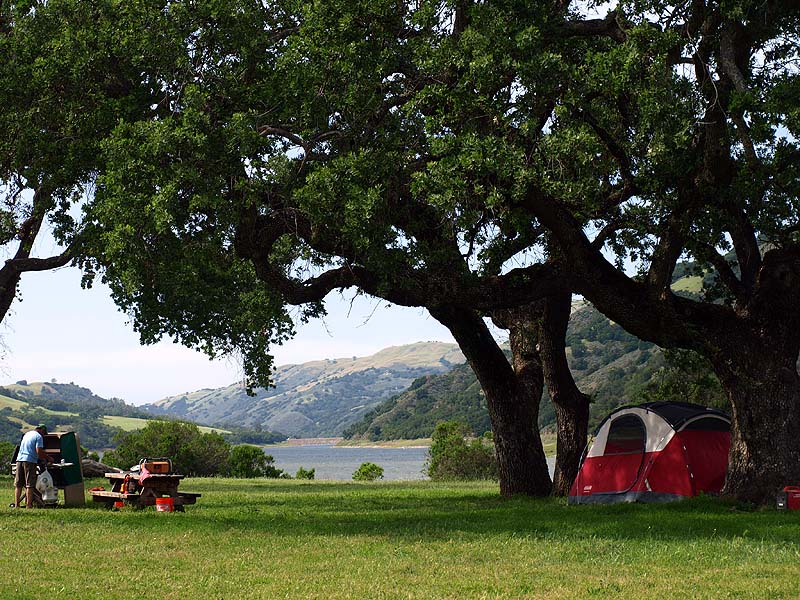
This campground site is in view of Coyote Lake.

This is another site near Coyote Lake.

This is the campground trail.

This is a closeup of a checkerbloom.

The grass is high along the Campground Trail.

There is a small stock pond, drying up and low, along the Campground Trail, with the north end of Mummy Mountain in the background.

This is a view from the upper end of the Campground Trail, looking back at the Valley Oak Trail, which is the leads off to the center left.

This is the junction of the Campground Trail and the Coyote Ridge Trail, with Mummy Mountain in the background.

This is a view from the Gaviota Trail, looking down at the valley between the Mendoza and Gaviota Trails.

This is a view from the Gaviota Trail, looking towards Gilroy.

The Gaviota Trail runs along the hillside and passes through a serpentine area, where the vegetation changes.

This is a view of the Gaviota Trail continuing along the hillside. This was the turn-around point.

This is a view looking down from the Gaviota Trail at the ranches in Gilroy bordering the park.

This is another view of the ranches bordering the park.

This a view looking back towards the north end of Mummy Mountain, with the Mendoza Trail running along its side. You can see the profile of the mummy, with the head on the left, the chest on the right, and the neck in the middle.
Page created by Ron Horii, 5/12/13