Links
Park Links
Coyote Lake - Harvey Bear County Park
Park Map
Hiking the Coyote Bear
Clampers Monument at the Harvey Bear Ranch
Santa Clara County Parks
SCCOSA Upper Coyote Area
Henry Coe State Park
Bay Area Ridge Trail
Friends of Santa Teresa Park
Pictures of the Park
Harvey Bear Ranch 3/10/07
Coyote Lake/Harvey Bear Ranch 3/20-21/09
Trail work Day on the Savannah Trail, 4/18/09
Coyote Lake/Harvey Bear Ranch 4/18/09
Mummy Mountain Trail Work Day/Trail Opening 4/24/10
Geocaching Class, Mummy Mountain Trail 5/15/10
Photography Class, Mummy Mountain Trail, 4/23/11
Willow Springs, Savannah, Rancho San Ysidro Trails, 12/22/11
Roop Pond and Rancho La Polka Trails 2/20/12
Photography Class, Mummy Mountain Trail, 4/7/12
Ed Willson Trail 11/10/12
Calaveras Trail Wildflowers, 4/9/13
Contact Ron Horii
Ed Willson Trail, Coyote Lake/Harvey Bear Ranch, April 9, 2013
The Ed Willson Trail is the newest
and last trail in Coyote Lake/Harvey Bear Ranch County Park. Ed Willson
was a ranch hand who worked for the Bear Family. The Bear Family owned
the ranchlands before they became part of the park. It was open on
4/21/12. I first hiked on the trail on 11/10/12 (see the link on
the left). At that time, the hills were all brown, and there were no
wildflowers out. I wanted to see how it looked in the spring, so I went
out on April 9, 2013. Though there was a lot of rain at the end of
2012, the first few months of 2013 were unusually dry. The hills were
just starting to dry up at the beginning of April, so I came just in
time. Compare these pictures with the ones I took last November.

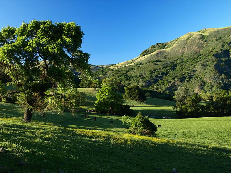
Next to the Harvey Bear Trail,
a herd of cattle is busy doing their job keeping the grasses down.

This is the trail map. Some
of the pictures below will refer to the letters on the map.

This is point A, the start of the eastern trailhead of the Ed Willson Trail.

There are California buttercups on the hill above the trail.

This is the bridge over the seasonal creek. The creek was dry.

This is a patch of pink owl's clover.

Grass has covered the trail, so it's hard to tell where it is, but the cattle have trimmed the grass short, so it's like walking on a park lawn.

These yellow flowers are big-scale balsamroots, a rare member of the sunflower family. They appear in patches on the hill.

More big-scale balsamroots.

Closeup of one of the big-scale balsamroots, along with creamsacs on the left and blue-eyed grass on the right.

The trail is a narrow footpath between rows of thistles.

The trail runs through a shady oak forest.


This is point B. The trail emerges from the oak forest and goes up and around a meadow.

The trail goes up along the hill.

View looking back down on the trail as it loops around the meadow below.


The trail passes by a forest on the right, a meadow on the left. High up on the hill is where the trail is going.

The trail begins to reach the edge of the meadow and starts to climb.

Yellow johnny jump-ups and blue miniature lupines.

The trail climbs up a rocky hill and passes through this tree arch.

On the other side of the hill, there are views of the ridges east of the park, Nesbit Ridge on the left, Sheep Ridge on the right. These are private property.

View back along the trail of the big open meadow.

The hill below the trail is covered with spring vetch.

This is point C, the northernmost point of the trail, right at the park's northern boundary.

This is the start of the long hill climb. Miniatures lupines are on the hill on the right.

There are several mule's ear sunflowers and lots of white Chinese houses on the hillside.

Bluedicks and buttercups are on the hillside above the trail.

Another mule's ear sunflower.

The trail climbs along the hillside through this shady forest.

Lots of flowers are along this rocky hillside.

The blue flowers are larkspur.

Wild peas.

More mule's ear sunflowers on the hill.

The trail passes by a grove of pine trees.

This is where the trail opens up to a vista. This is the view looking back towards the north.

This is point D. The pictures below are panoramic views from this lookout point.

This wooly-leaved plant is a California milkweed. There are many of these on the hilltop.

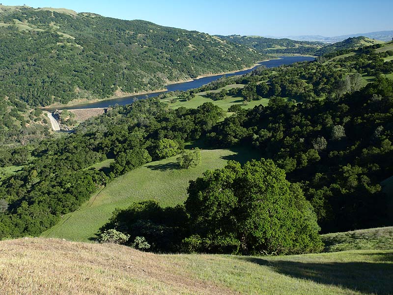
View of Coyote Lake.

Closer view of the Coyote Lake Dam and spillway.

Zooming farther in on the spillway.

Zoom-in on the Harvey Bear Trail and the start of the Ed Willson Trail.

View along the park's ridgeline.

Zooming in on the ridgeline. The Harvey Bear Trail crosses below it. The Coyote Ridge Trail climbs up along the ridgeline on the upper right.

Zooming in below the ridgeline, the Ed Willson Trail on the right ends at the Harvey Bear Trail. The Coyote Ridge Trail climbs up the hillside from center right to upper left.

Zooming in further on the Coyote Ridge Trail.

Zooming in, a hiker on the Harvey
Bear Trail approaches the junction
with the Coyote Ridge Trail, which heads uphill to the left, while the
Harvey Bear Trail goes downhill to the right. The Bay Area Ridge Trail
follows the Coyote Ridge Trail, so this is the
northen end of the Ridge Trail in Coyote Lake/Harvey Bear County Park.
The next segment of the Ridge Trail doesn't start until the Coyote
Creek Trail at Anderson Lake County Park.

View looking across the park's foothills towards Gilroy.

Zooming in more, the Ed Willson Trail crosses from the right, leading to the Harvey Bear Trail on the left.

View looking towards San Martin.

Zooming in, the patch of green grass to the right of center is the flat field at the Harvey Bear Ranch entrance of the park in San Martin. The paved Martin Murphy Trail runs around this field and is the only paved multi-use trail in the park. The next few pictures are telephoto views from south to north from Gilroy to Morgan Hill.


El Toro Mountain in Morgan Hill, with the Sierra Azul Range in the background, topped by Mt Loma Prieta on the left.

Looking across Morgan Hill. In the background is Mt. Umunhum.

The trail climbs up the narrow ridge. There are only a few trees on top of the ridge. A large coast live oak is on the left.

The trail switches back to the east side of the ridge and makes one last climb uphill to the high point of the park.

Ahead is the high point of the park, just past the big bay laurel trees.
View looking back towards Coyote Lake. Down below, the trail runs along the edge of the big open field.

Approaching the edge of the park.

This is point E, looking at the private lands north of the park. Finley Ridge is on the left. Nesbit Ridge is on the right. Otis Canyon is in the center.

The fence marks the park boundary. The hill beyond is private. If it were not there, you could see Coyote Creek where it flows into Anderson Reservoir.

The highest point in the park is near here. The trail runs around it and heads downhill. From here, it is mostly open hillside, with almost no shade. These huge bay laurel trees, seen on the ascent, provide the only real shade.

Ahead is point F, where the trail makes a U-turn and heads downhill.

Looking ahead from point F, the trail goes down and turns to the left.

This is point G at the northwest corner of the park. Below is a stock pond.

The trail begins its long, gradual descent along the wide open hillsides, with unobstructed views to the west.

Looking down towards Gilroy.

Looking back uphill along the trail.

Ahead by the lone oak tree is the end of the Ed Willson Trail at the Harvey Bear Trail.

This is point H, the western trailhead at the junction with the Harvey Bear Trail. I take the Harvey Bear Trail back to the start.

Looking east across the meadow by the Harvey Bear Trail, Sheep Ridge towers high above on the right. Nesbit Ridge is on the left. Larios Canyon is in-between.

Cattle graze in the meadow, with Nesbit Ridge in the background.
This is a view again of the start of the Ed Willson Trail's eastern leg.

The Harvey Bear Trail leads down to the parking lot by the dam.

North of the trail, the hill drops steeply above the Coyote Creek canyon.

A deer grazes above the
Harvey Bear Trail, about 1/10 mile before it ends by the dam.
For more information, see the
links on
the side. See the webpage on the 11/10/12 hike on the Ed Willson
Trail for 3D satellite maps of the trail. For copies of these and
other pictures, contact Ron Horii
(see links).
Page created by Ron Horii,
4/23/13